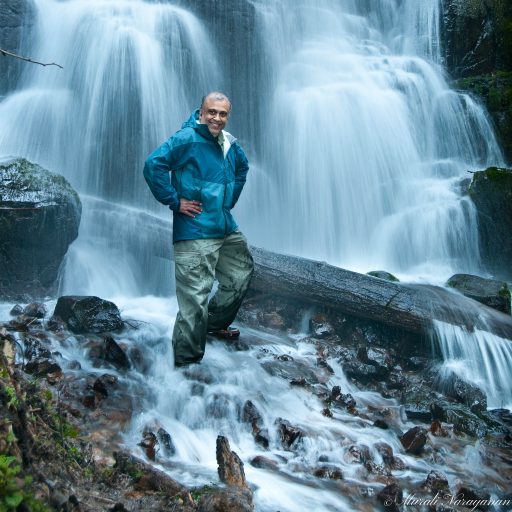
Iceland – March 17, 2016 (Day 1)
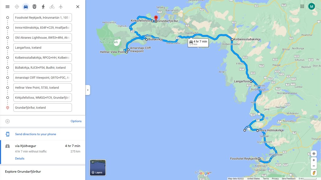
Mar 17 – Drive Map (click to see the map)
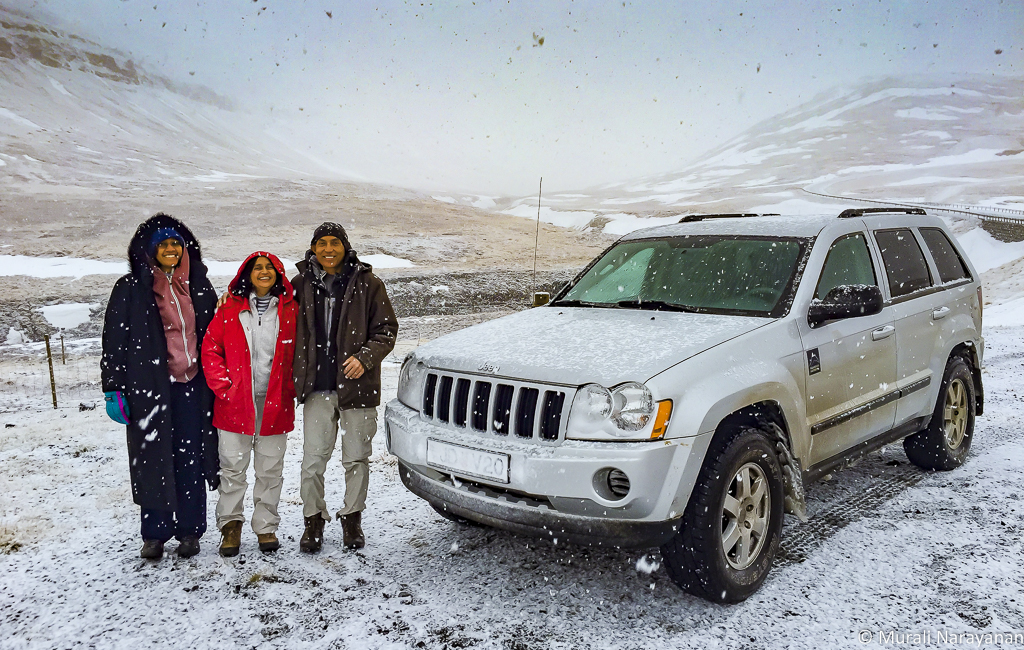
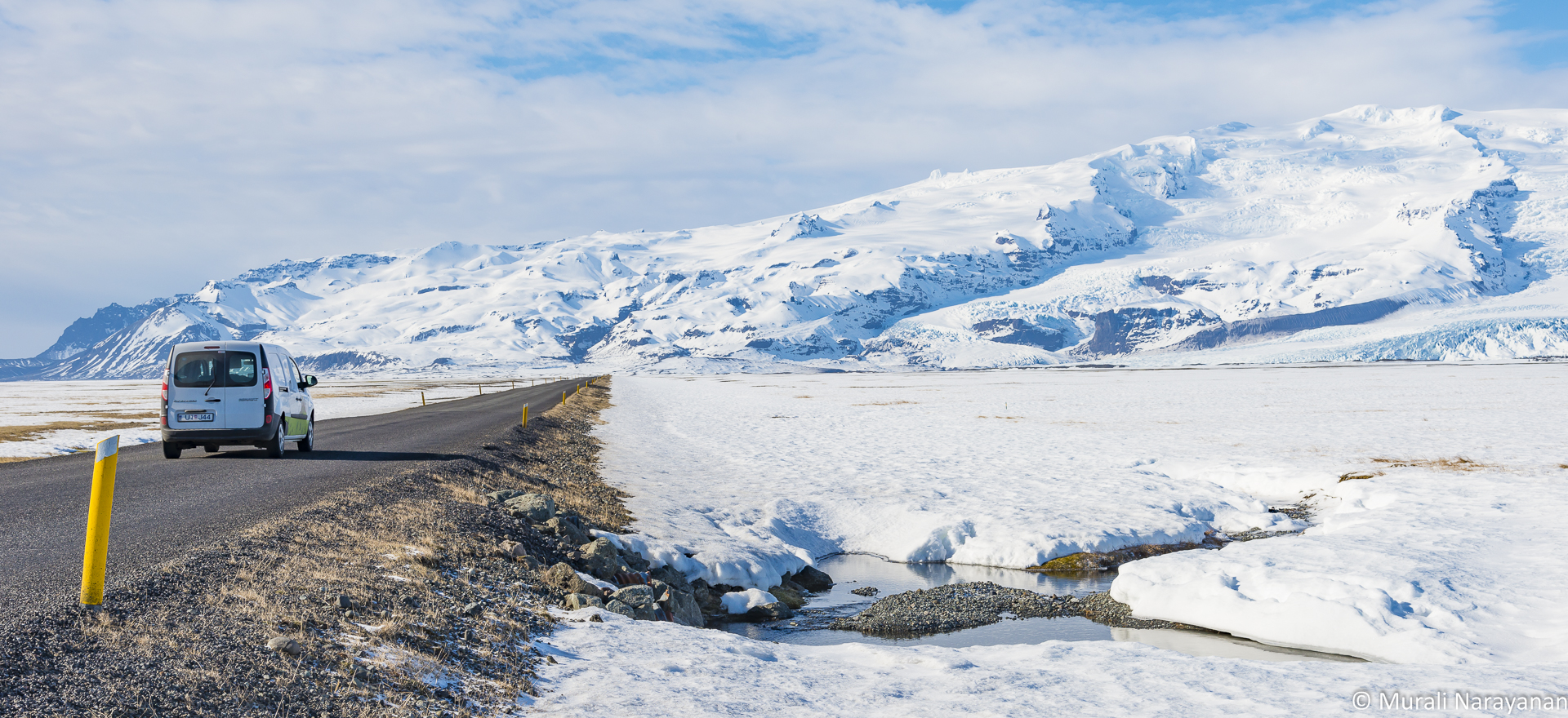
I landed at the Keflavik International Airport from Seattle at around 0915. Going through customs and immigration was a breeze. I didn’t have to fill out any forms – just showed the passport and walked to Baggage Claim. I was picked up by my cousins Indu, Bala, and Susheela who had flown in the previous night from Bangalore/India and Singapore. Bala had rented a rather beat up silver Jeep Grand Cherokee the previous day and we loaded the car and went to the rental car location to add me as the 2nd driver as you have to pay extra to include a second driver to the rental car agreement.
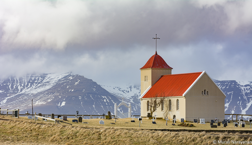
Our first stop on the way to Reykjavik was the beautiful Kálfatjarnarkirkja church surrounded by lava fields in the town of Vogar.

Almost all the churches we visited in Iceland including this were locked and we walked around it and shot a few images. Most likely the churches are open only during the summer.
We then drove to Reykjavik in search of a grocery store to grab snacks, fruits, veggies for the next 2-3 days of the trip. We found a Bonus (a grocery store chain in Iceland) near the highway. After 30 min of shopping, we checked into Fosshotel Baron at Noon. The hotel’s location is terrific and close to restaurants, nightlife, and Hallgrimskirkja. The rooms were small compared to US standards but comfortable. A tip: Get a room with a view of the water. After taking a shower in a sulphur infused water, we walked to Kryddlegin Hjortu, a very good reasonably priced restaurant that had a good vegetarian/vegan friendly menu. After a healthy consumption of soup and salad, we returned to the hotel to start the afternoon tour of Reykjavik.
The fist stop was at the Sun Voyager sculpture (Sólfar), a block from the hotel on Sæbraut. It is a big Viking ship steel-sculpture by Jón Gunnar Árnason (1931-1989) and a reminder of Iceland’s history and heritage when the first Viking settlers landed. Below is the picture of my cousins at the sculpture with a breathtaking background.

Then we drove northwest to Seltjarnarnes (a suburb of Reykjavik) to checkout the Grotta Lighthouse. Not as colorful as a lot of lighthouses in Iceland, this was the first one we encountered. As usual, the sun was playing hide and seek and winds blowing at 30 mph or so. From the parking lot, there is a very good trail to the lighthouse and we saw a lot of families with kids and dogs on the trail. Tip: This is a very good spot in Reykjavik to view Aurora Borealis in winter.
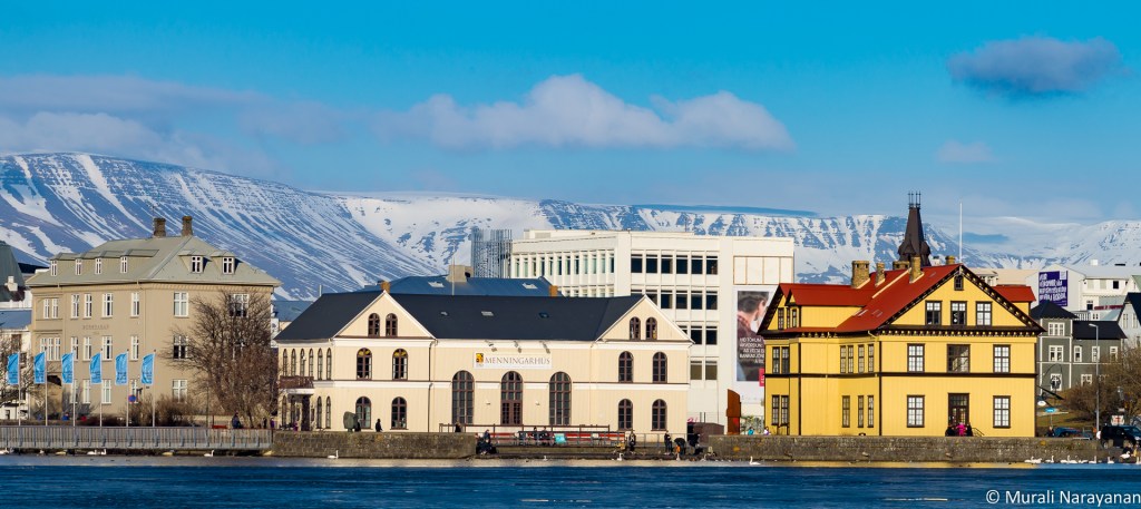
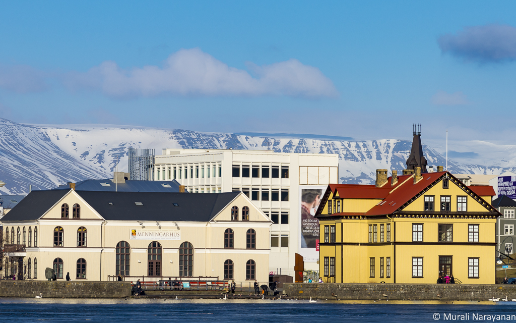
After spending about 45 minutes around the area, we drove back to our hotel. On the way, we stopped at a small mostly frozen lake called Tjörnin in downtown. From the western shores, you can experience a beautiful view of Reykjavik downtown.
We returned to the hotel from Tjörnin and dumped the photography stuff (2 bags and a tripod) in the room and walked to a very good high end Indian restaurant in Reykjavik, Austur India Fjelagid. The choices were rather limited but the food was excellent.
At 10pm we were picked up for an Aurora Borealis (AB for short in future pages) chase as the forecast was reasonably good. We chose to go with a tour as we were lazy to track the weather and drive on our own. It cost us US$50/person. A more expensive option is go in a Super Jeep tour that may set you back $150/person but you don’t have to deal with 50 others and these Jeeps can go to certain spots where the big coaches can’t. The cheapest option is to drive on your own but you should know where you should go and be prepared to deal with snow/icy road conditions in the middle of the night. The big coach drove us north on Route 47 that runs parallel to the Hvalfjörður fjord. Unfortunately it was pretty cloudy. The tour guide told us a lot of stories and history about Iceland that were both educational & entertaining. We stopped twice to look for AB with no success. We were finally dropped back to the hotel around 2am without seeing AB. The tour companies generally give you a free ticket for another chase but we couldn’t make use of them as we had other plans. We had a short sleep that night so that we could start on Day 2 activities bright and early.
March 18, 2016 (Day 2)
2nd Day was devoted to covering Iceland’s Southern peninsula. Key spots visited were the 2 lakes on Route 42, Grindavik including its beautiful lighthouse, Gunnuhver Hot Springs, The Bridge Between Continents, and 3 lighthouses around Reykjanesbær – covering close to 125 miles. Was quite a busy day.
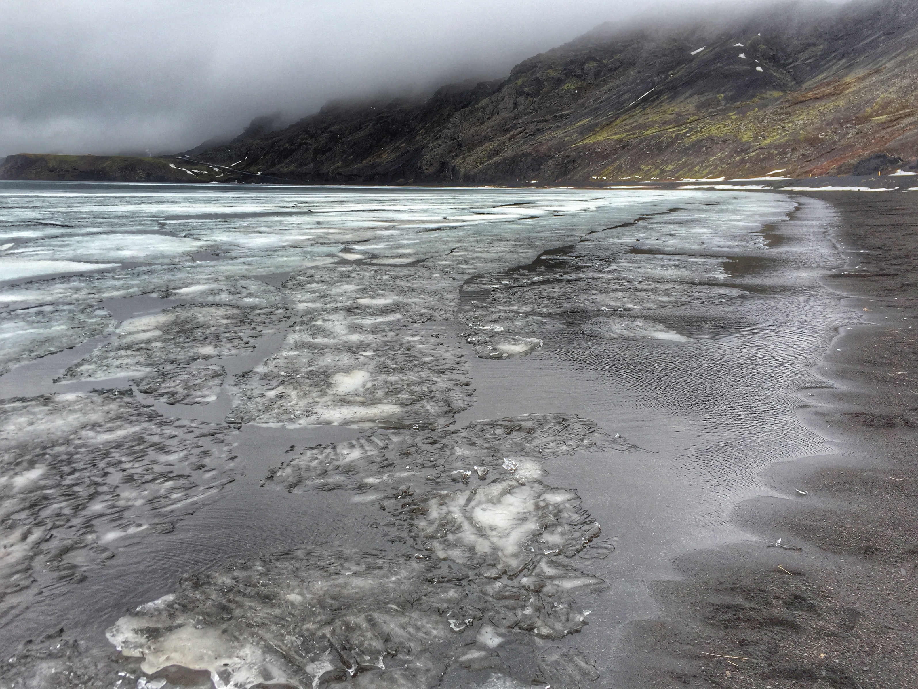
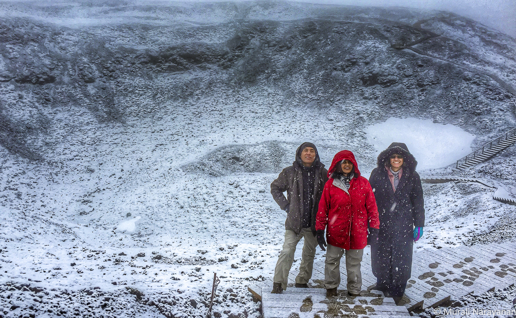
After having an early breakfast, we started driving to Kleifarvatn on Route 42, a gravel road. For the next 2 hours or so, we were blasted by winds with speeds of over 40 mph and the temperature was a tad under freezing. Out came all the winter outfits especially Indu’s now the world famous red jacket!!! We will not talk about Susheela’s tough look outfit 🙂 Setting the tripod and mounting the camera became challenging.
It was so windy & cold at Kleifasrvatn, I decided not to take out my Nikon outfit and shot this image using an iPhone6.
Krýsuvík consists of several geothermal fields, such as Seltún. Here solfataras, fumaroles, mud pots and hot springs have formed, the soil is colored bright yellow, red, and green hues – a miniature version what we see in Yellowstone NP. Cold water streams and boiling hot water streams flow side by side here.

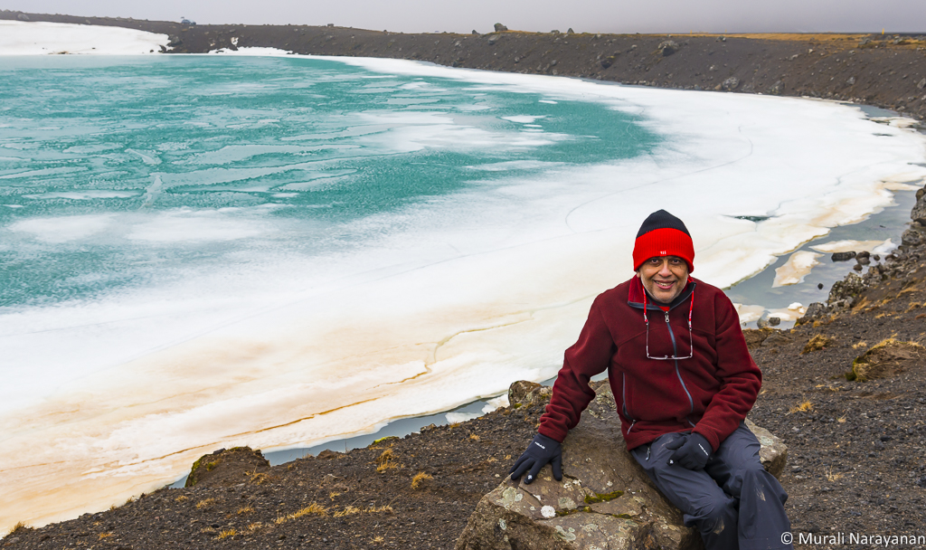
Next to Krýsuvík Geothermal Area is another nearly frozen lake called Graenvatn (aka Green Water). Icelandic naming convention is very rational. When you see the lake you know how it got its name. Here is a picture of me shot by Indu.
After enjoying scenery around Graenvatn with winds howling at over 40 mph, we headed towards the fishing town of Grindavik in the Southern coast of Iceland. Along Route 427 (back on a paved road) are massive lava fields covered with moss. We stopped to take some pictures.

When we got back into the car, it wouldn’t start. We had heard that rental cars in Iceland are not super reliable compared to the US and the Jeep we had rented was US made and had about 125K miles on it. We suspected that the battery might have lost all its charge. Bala called the rental car company (we had cell phone coverage pretty much every where we went and we procured multiple SIM cards each for about $15 that included 1GB of data) and the guy asked Bala to put the car in neutral and try to restart. It worked!!! This happened once more during the trip.
Near Grindavik, we came across this cute looking red colored shack on a massive black lava rock. The contrast was striking.

We reached Grindavik at around 1230 pm – time for pizza, the only vegetarian option in Grindavik, a town where u can smell fish everywhere. We had excellent salad and pizza at Pappa’s Pizza. The owner was super friendly and met our unique demands around types of vegetables.
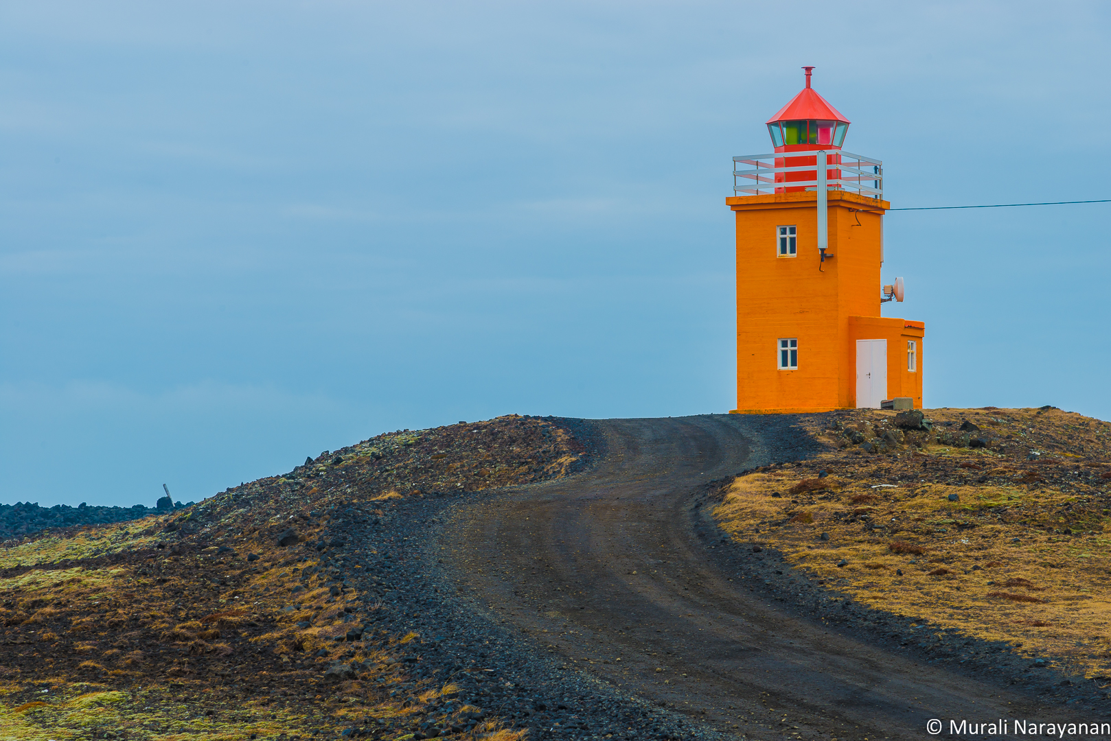
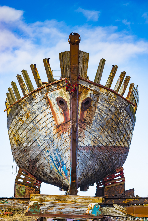
At the pizza place, we saw a travel brochure that had a picture of a terrific looking lighthouse. The Jeep was destined to stop at every lighthouse and waterfall. The Pizza place owner gave us the directions and the lighthouse chase began. The 26′ tall Hópsnesviti Lighthouse built in 1928 currently painted in bright orange was about 2 miles from Grindavik on an unmarked gravel road. On the way, we passed by a number of shipwrecks cast ashore by the ocean, never pulled or left there by any other means.
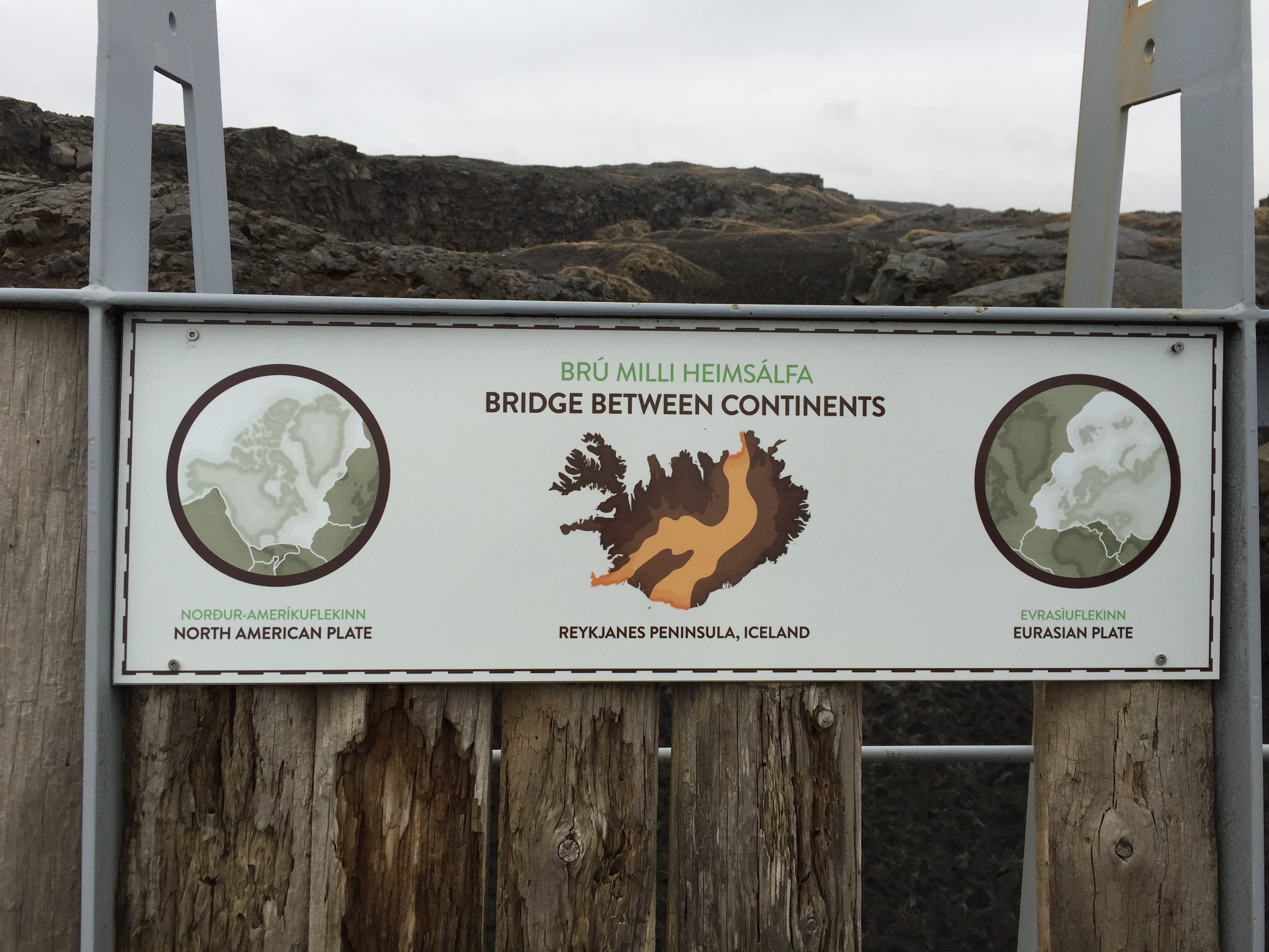
After a short stop at the Gunnuhver Geothermal area, we reached the Bridge Between Continents, a thin steel span in the middle of nowhere, crossing the rift separating the North American and Eurasian continental plates. We walked across the bridge.

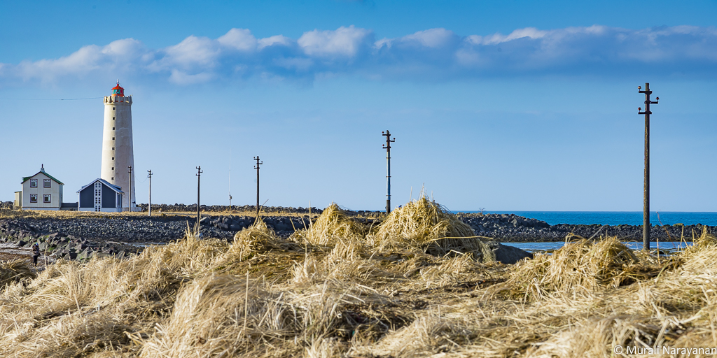
We then drove north to the tip of the Reykjanes peninsula to the small town of Gardur to checkout 2 lighthouses that are side by side. The old Garðskagi Lighthouse was built in 1897 and was used until recently as a center for studying the thousands of migrating birds which arrive there from Greenland and North America every year to breed on the surrounding shore.


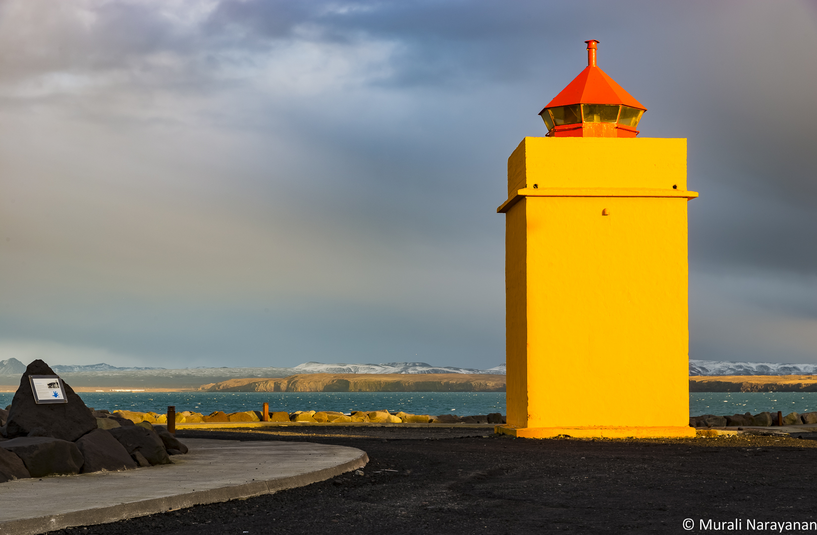
We checked out one more lighthouse near the Keflavik International Airport that was not marked in Google Maps or in any travel guide. It was located next to a quarry. It snowed during the night before we left Iceland & I went back before returning the rental car to shoot an image of the lighthouse surrounded by rocks with snow.

We reached our hotel back in Reykjavik at around 730 pm. We then walked to Meze, a Greek/Turkish/Middle eastern restaurant and consumed a few appetizers. After dinner, we drove to the famous Hallgrímskirkja (a Lutheran Church). The 240+’ structure is visible from mostly anywhere in Reykjavik and surrounding areas. We returned to the hotel at around 10 pm. As the Kp index that night was just 2 and it was very cloudy, there was no chance to see Aurora Borealis and so it was time to go to sleep thinking about Day 3.

March 19, 2016 (Day 3)
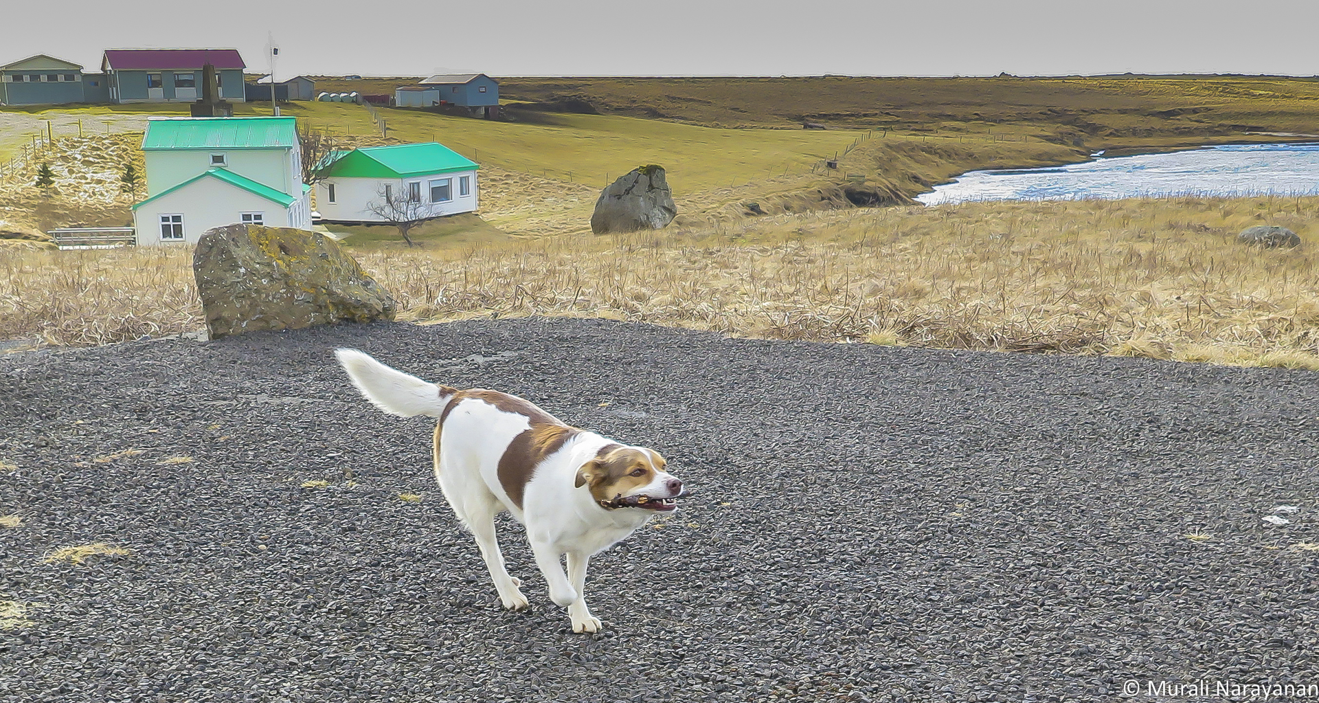
Day 3 was a day for churches and waterfalls with spectacular mountain landscapes between Reykajavik and everywhere in Snæfellsnes Peninsula, total driving distance was about 175 miles. We refueled the car in Reykajavik, collected some cash at at ATM (later we realized that you really don’t need any cash as credit cards are accepted pretty much every where) and headed to the town of Akranes, an hour drive north of Reykjavik on the Ring Road, aka Route 1. Ring Road, completed in 1974, is about 800 miles long and circumnavigates the whole country. It is paved and outside of Reykjavik, it is pretty much one lane in each direction. We hit the first church (Innra-Hólmskirkja) just before we reached Akranes. While I was busy photographing, the trio were entertained by a dog in the house next to the church.

We wanted to see 2 spots in Akranes, a lighthouse and a shipwreck called “Höfrungur” (Dolphin). We hit the lighthouse first. In fact, we found 2 lighthouses, side by side. The smaller and more elegant one was built in 1918. This is also a very good spot to photograph Aurora Borealis in the winter.

Next stop was to “Höfrungur”. It was locked behind a small shipyard where a bunch of boats were being repaired. It was originally built in 1955 but it is no longer in use.
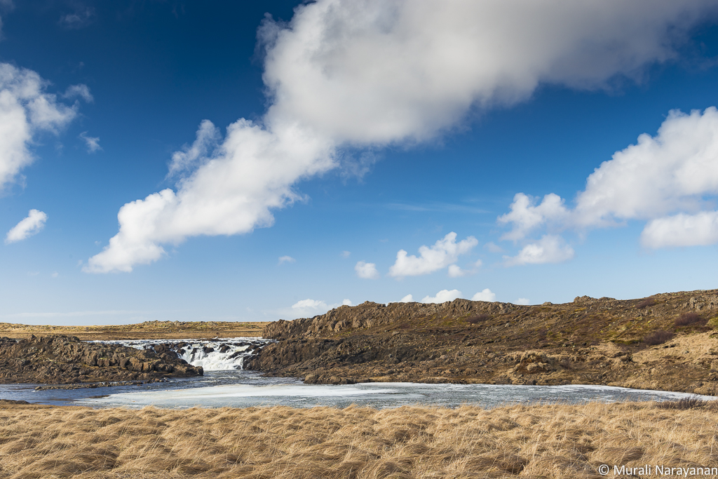
It was close to 1030 am and time for a coffee/hot chocolate break. Found a coffee shop in the main street. By the time we went in, it started drizzling. In Iceland, if it rains, wait for 10 minutes and you will have sunshine and vice versa. After coffee/hot chocolate, we started driving to the town of Borgarnes. We shot a picture of the church there and then got back on the road towards SnæfellsnesPeninsula on Route 54. We encountered the first waterfall, Langárfoss, located very close to the road. The falls drop about 10 feet where the river flows through a protrusion of volcanic rock, splitting into several channels.
Time for lunch. As there were no restaurants anywhere near there, Indu and Susheela prepared bagels, fruits, and some Indian snacks. We realized that we were about 2 hours behind schedule and started driving towards the town of Búðir. When we stopped at the next waterfall, a very persistent dog dropped a branch/stick at my foot and started barking like crazy. I was trying to photograph the falls and the dog wouldn’t let me alone. I threw the stick away and it immediately ran, grabbed the stick and dropped it under my feet and started barking. This cycle went on for 5 minutes. Then I threw the stick to my cousin Bala and he continued the game for another 15 minutes or so. Finally we had to continue our drive feeling a bit sad.


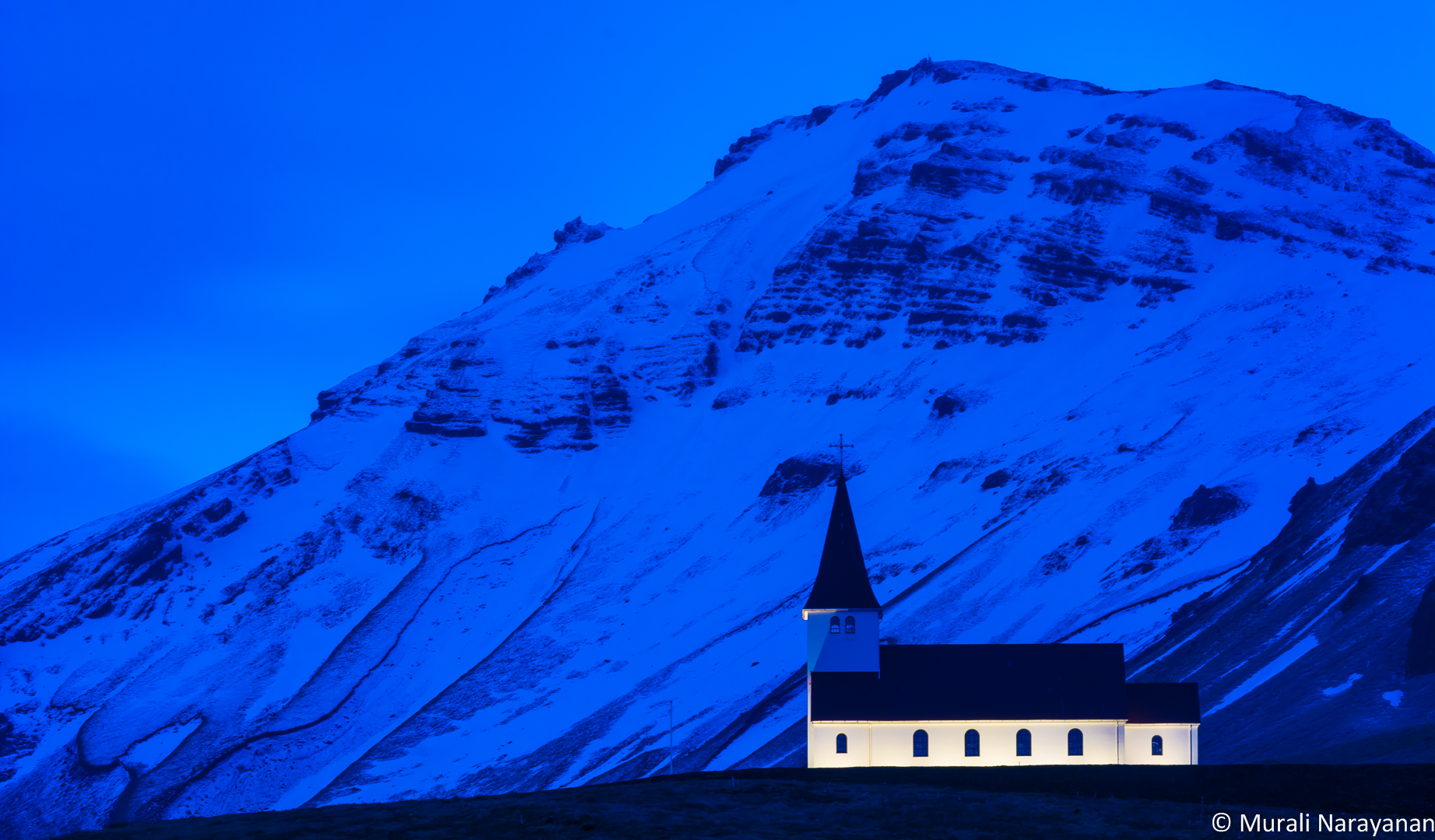
As we approached Búðir, we came across 2 more churches with spectacular mountains as backgrounds worthy of photographing.
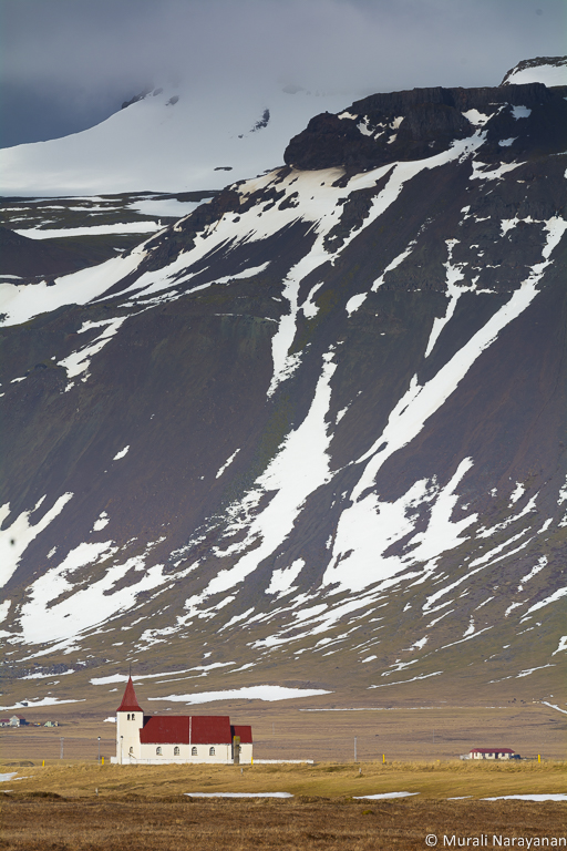
It was close to 4pm, 3 hours behind original schedule, when we reached Búðir. It is a small village in Búðahraun lava fields in Staðarsveit, on the westernmost tip of the Snaefellsnes peninsula where Hraunhafnará river falls to the sea. The world renounded Budir Hotel and the Budir Church are located here. The location of the church is terrific, Atlantic ocean in the front and the Snæfellsjökull glacier behind it. Built in 1848, it is one of 3 black colored churches in Iceland. This is also another great spot to photograph Aurora Borealis.

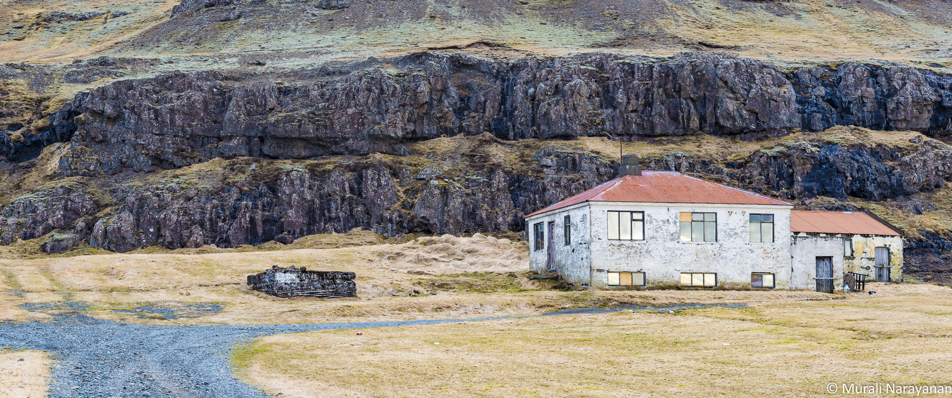
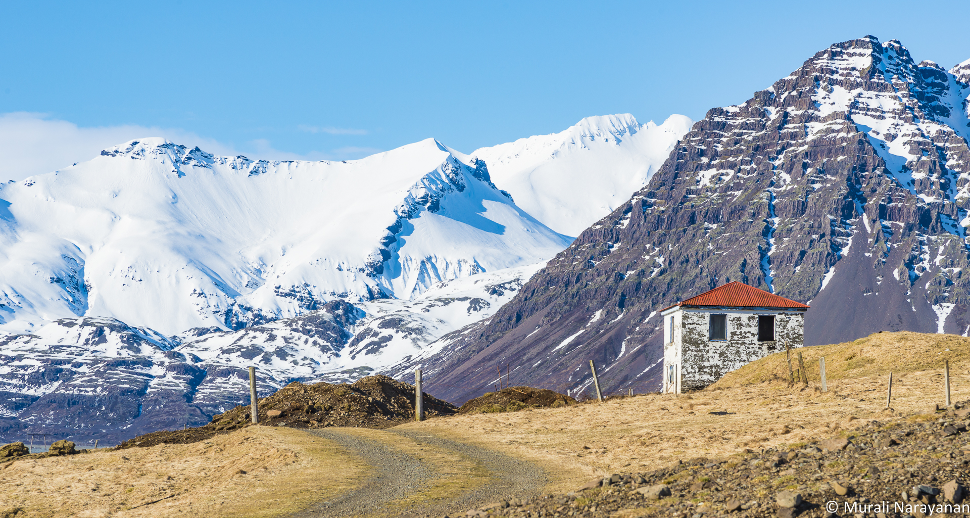
Next stop after Budir was another coastal town of Arnarstapi, a small fishing village at the foot of Mt. Stapafell. It is still a somewhat busy harbor during the summer months serving private fishing and recreational vessels but there was hardly anybody when we were there. There was one restaurant/pub but it was closed. Light was also harsh and so the photography opportunities were rather limited. We found a lonely house near the harbor that was good to photograph. There are more options to photograph around the village in the mornings compared to afternoons/evenings.

After spending 15 minutes or so in Arnarstapi, we headed to Hellnar, a small fishing village, a cluster of old houses and buildings. There was one restaurant that was closed. It looks like a lot of establishments in the SnæfellsnesPeninsula are only open in the summer. We hardly encountered anybody but we saw 2 spectacular sites – the Hellnar church and the rock formations jetting into the Atlantic Ocean.


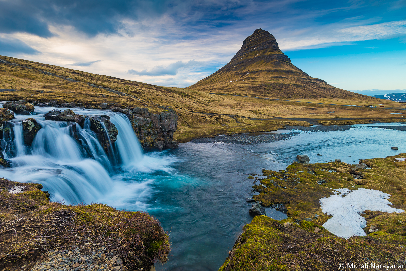
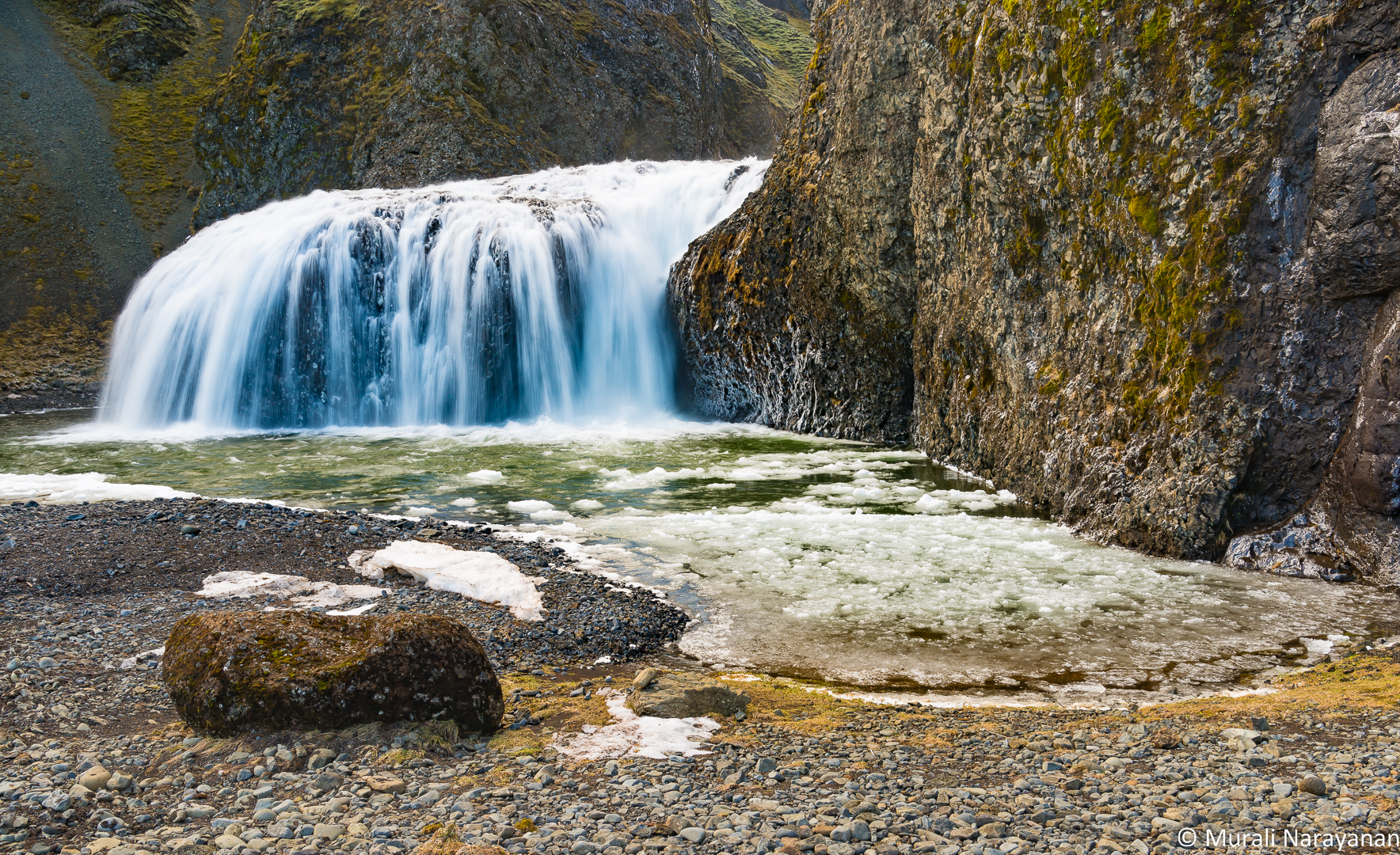
Sunset was an hour away when we left Hellnar. As it was getting dark, we skipped a bunch of spots and headed to our destination for the night, Grundarfjörður. We decided to checkout the iconic Kirkjufellfoss waterfall and Kirkjufell Mountain at the edge of the town. Light turned spectacular and it gave me the opportunity to shoot one of the best images of the trip. I was initially hesitant to take out my gear thinking I could take a better image in the morning but when I saw the sky, I changed my mind and good I did that as the sky was pretty bland next morning.
We checked into our 2-bedroom apartment at the Grundarfjordur Guesthouse and Apartments. At the entrance of the guesthouse was a sign instructing guests to remove their shoes prior to entering the apartment. We encountered this in all the hotels and guesthouses we stayed in outside of Reykjavik and Keflavik. We totally enjoyed the informal treatment. The apartment had a kitchen with utensils, detergent, etc and 2 bunk beds in the main hall. The 2nd room had 2 beds as well. Overall, not fancy but comfortable. Bala made a huge salad and spaghetti marinara with garlic bread for dinner. No Aurora Borealis that night as it was cloudy and rainy. 3 nights for me and 4 nights for the trio and we were yet to see the Northern Lights :-(. It was a long day of driving and so we hit the sack at around 10pm thinking about Day 4.
March 20, 2016 (Day 4)
Relatively less driving with less luggage in the trunk on Day 4 when we spent the whole time driving around the northern shores of Snæfellsnes Peninsula between the towns of Hellissandur and Stykkishólmur. As usual, the day started with a bit of rain, biting cold, and strong winds and so it was time to chase waterfalls. As we had a good darshan of the Kirkjufellfoss & the Kirkjufell Mountain the previous evening, we decided to hit the Baejarfoss in the town of Ólafsvík first. It was terribly windy when we parked the car behind an apartment building on the southside of the town and took a short hike up to the falls with a little bit scrambling.
After Baejarfoss darshan, we took a very short pit stop in front of the Ólafsvík Football stadium and the church next to it we drove west to the town of Hellissandur.

Hellissandur is a village on the northwest shore of the Snæfellsnes Peninsula with a few interesting places to see. One was the Icelandic turf house. Icelandic turf houses were the product of a difficult climate, offering superior insulation compared to buildings solely made of wood or stone, and the relative difficulty in obtaining other construction materials in sufficient quantities. We spent about 20 minutes walking around and inspecting the house from the outside. Also notice along the left edge of the image below the 1350′ communication antenna which is the highest in Western Europe. The structure was built by US army during the cold war. Today the antenna is used by Iceland national broadcast company.

After visiting the turf home, we headed to the western tip of the peninsula to see the Svörtuloftiviti Lighthouse. After leaving the main road, a smaller but very rough road wound tightly through lava fields for about 15 minutes before we arrived at the beautiful orange structure. The scenery around the lighthouse was spectacular including amazing rock formations. We walked on the lava field for 30 minutes or so socking in the majestic scenery while the weather was switching between sunshine and light drizzle every 5 minutes. As usual, there were just 3-4 couples vising the area. In general, we hardly saw anyone (tourists or locals) during the 2 days we spent in the Snæfellsnes Peninsula.


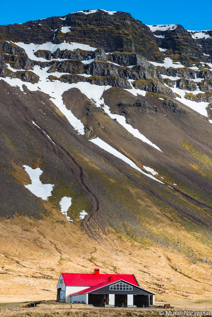
It was past 1pm when we drove back to Ólafsvík in search of a restaurant for lunch. Hraun, a restaurant/pub looked enticing from the outside based on the number of cars parked in front of it. We ordered 2 veggie pizzas. After lunch we retraced our route back to Grundarfjörður and no clouds were to be seen anywhere. Along the side of the road we saw a cute red roofed barn next to a farmhouse. By this time, the trio had figured out that the car stops anytime it locates a red or orange colored structure near the road. Bala found a small patch on the side of the road and squeezed the car into it. Out came the camera bag & the tripod. A few shots were taken.
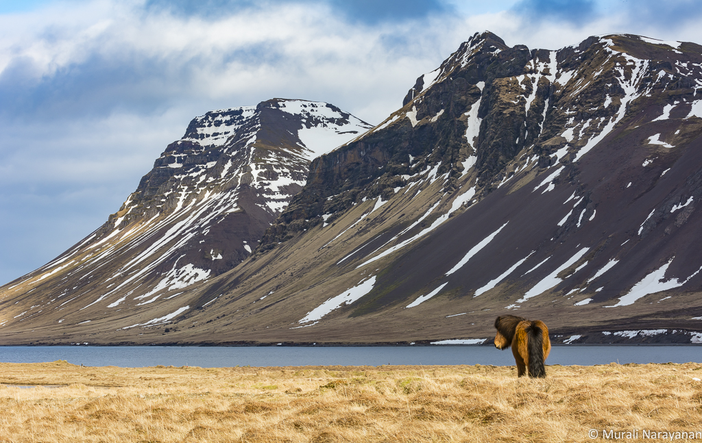
Then we headed out to the northeast section of the peninsula towards the town of Stykkishólmur. Along the way, Susheela spotted 2 Icelandic horses. They were totally uncooperative and were just standing still like statues with showing their butts most of the time.
We then we drove to Bjarnarhöfn where there was a church built in the 1800s. It was about 15-20 miles from the main road but when we reached there, we did not find much. May be my lat-long was wrong. Anyway, it was a disappointment. Then Bala realized that the car was running on reserve and the nearest gas station was 15 miles away. We were joking that if we ran out of gas we can have Indu, the marathoner, should do a sprint to fetch 2 gallons of gas to get to the gas station. We reached Stykkishólmur by 530pm without any issues. If my mom were in the car, she would have promised breaking 101 coconuts!!! We went to the harbor first to view the small lighthouse.

It was time for coffee/hot chocolate and toilette break. We walked to the Narfeyrarstofa cafe next to the marina and had the drinks and a carrot cake. Sun was setting and so we quickly went to the Stykkishólmskirkja church in town to take a few pictures.
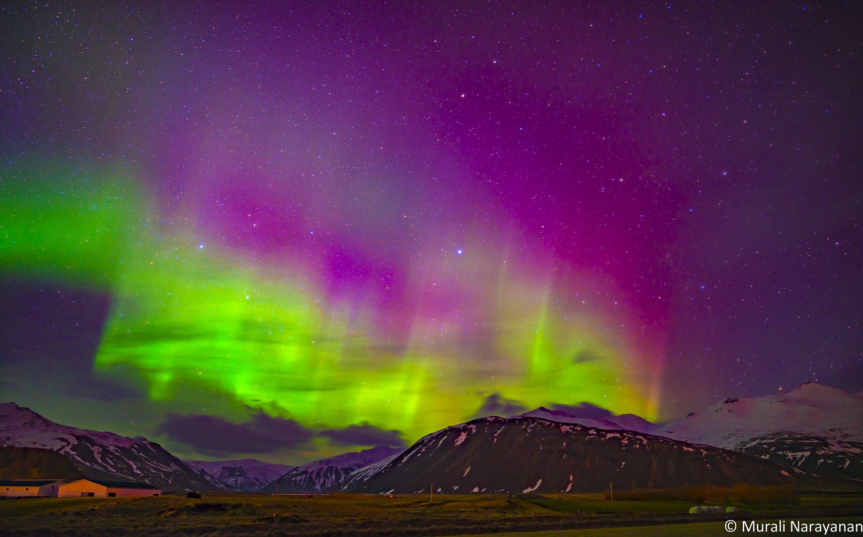
After picking up groceries in Stykkishólmur Bonus grocery store and filling up gas, we returned to our apartment back in Grundarfjörður. Bala again made salad and spaghetti for dinner. The sky was clearing a bit at around 1030pm and we decided to walk out to the front of the apartment. We saw a Chinese couple with a cameras mounted on tripods and talking in excited voices. Ha, it should be Aurora Borealis time. Susheela & Indu were good AB spotters and both noticed a slight green pattern in the sky. The Kp index that night was rated a 3. I took my 1st shot of the AB with the Rokinon 24mm f1.4 lens that was purchased just for this occasion. The image on the LCD screen looked pretty good but when I processed the images in Lightroom back in the apartment, excitement quickly turned into a disappointment. The Kirkjufell mountain that was the foreground was not in focus. I trashed all the AB images. It was now time to go to bed imagining Day 5.
March 21, 2016 (Day 5)
Day 5 turned out to be a long driving day from Grundarfjörður to Gullfoss, a distance of 250 miles. First stop was at Grábrók. We decided to take an unpaved Route 60 scenic road rather than the paved and faster Route 54. Grábrók is a volcanic crater about 20 miles northeast of Borgarnes on Route 1 (aka the Ring Road). The scenery along Route 60 stunning and the sun was continuing to play hide and seek. Soon it started to drizzle but the unpaved road was okay. Bala did a terrific job of driving in the rain and strong winds. Just before we reached Grábrók, the rain changed to snow due to increase in elevation.
Although it started to snow, we decided to climb up to the rim of the crater, a height about 500′. Was a good exercise but due to snow and super cloudy weather, visibility was poor and we couldn’t see the valley below. There was nobody to be seen anywhere between Grundarfjörður and Grábrók other than a dog near a church. The trio had a terrific time playing with the dog that hugged all.
We climbed down and checked into a cafe near the crater for a hot chocolate and Icelandic chocolates. Fed the car as well as the tank was half empty. Then we drove to Glanni (the only waterfall name without the “foss” (thanks to Kiana-Rvk at Tripadvisor.com for correcting me). We parked the car in front of the Glanni Golf-course clubhouse and did a short hike to checkout the waterfall.

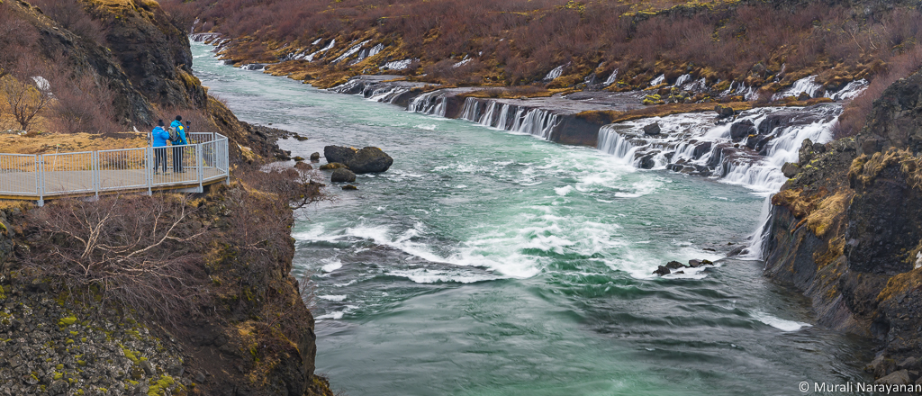
From Glanni we headed to Hraunfossar, a series of spectacular (in Iceland, u can use the adjective “spectacular” to pretty much everything you see!!!) waterfalls formed by rivulets streaming out of the Hallmundarhraun lava field (Hraun = Lava in Icelandic). Wow, it was an amazing site with a lot of photo opportunities. As this is a part of the “Golden Circle” tourist route, we started seeing hoards of tourist buses, huge and small. We had to deal with this challenge for the next 8 days until we reached the town of Höfn in the southeast corner of Iceland. I cant image the Golden Circle in the summer – definitely worth avoiding. By the time, we walked around the falls, it was past 1pm and so it was time for lunch. We ate a bagel and fruits as there were no restaurants nearby.

From Hraunfossar, the next stop was the famous town of Þingvellir. On the way, we came across a small but super cute church attached to a farm near Reykholt. The car automatically stops at any structure with a red roof. We got down and shot a few pictures.
The drive to Þingvellir via the 4 mile tunnel under the Hvalfjörður fjord took about 2 hours. It is one of the most popular tourist spot on the Golden Circle and a site of historical, cultural, and geological importance. It lies in a rift valley that marks the crest of the Mid-Atlantic Ridge. It is at the northern end of Þingvallavatn, the largest natural lake in Iceland. Unfortunately, due to my poor planning, we did not have the time to explore some of the key spots like the The Alþingi (assembly) that was Iceland’s supreme legislative and judicial authority from its establishment in 930 until 1271. It was late afternoon when we hiked to the Öxarárfoss.

From Öxarárfoss, we drove to Gullfoss without stopping anywhere. It was super windy and drizzling when we reached the falls and decided not to venture out of the car. We then checked into the very good Hotel Gullfoss. We got rooms in the back of the hotel that had a terrific view of the Ölfusá river. Just like in the apartment at Grundarfjörður, we had to remove our shoes at the lobby before going into the rooms. The staff at the hotel were super friendly and the rooms were modern and comfortable. I highly recommend it. The Aurora Borealis (AB for short) forecast was rather good with the Kp index of 3. By 930pm, the sky had cleared a bit and we got a good AB darshan with our naked eyes for about 20 minutes. The pictures I took came out better than the ones at Grundarfjörður but the foreground (a dump truck) was unimpressive. We were also lazy to locate a better spot. In hindsight, we should have driven to Gullfoss as the AB was in the west of the hotel.

Finally saw a good AB on Day 5. The best is yet to come on Day 10 :-). All went to bed quite satisfied and thinking ahead to Day 6.
March 22, 2016 (Day 6)
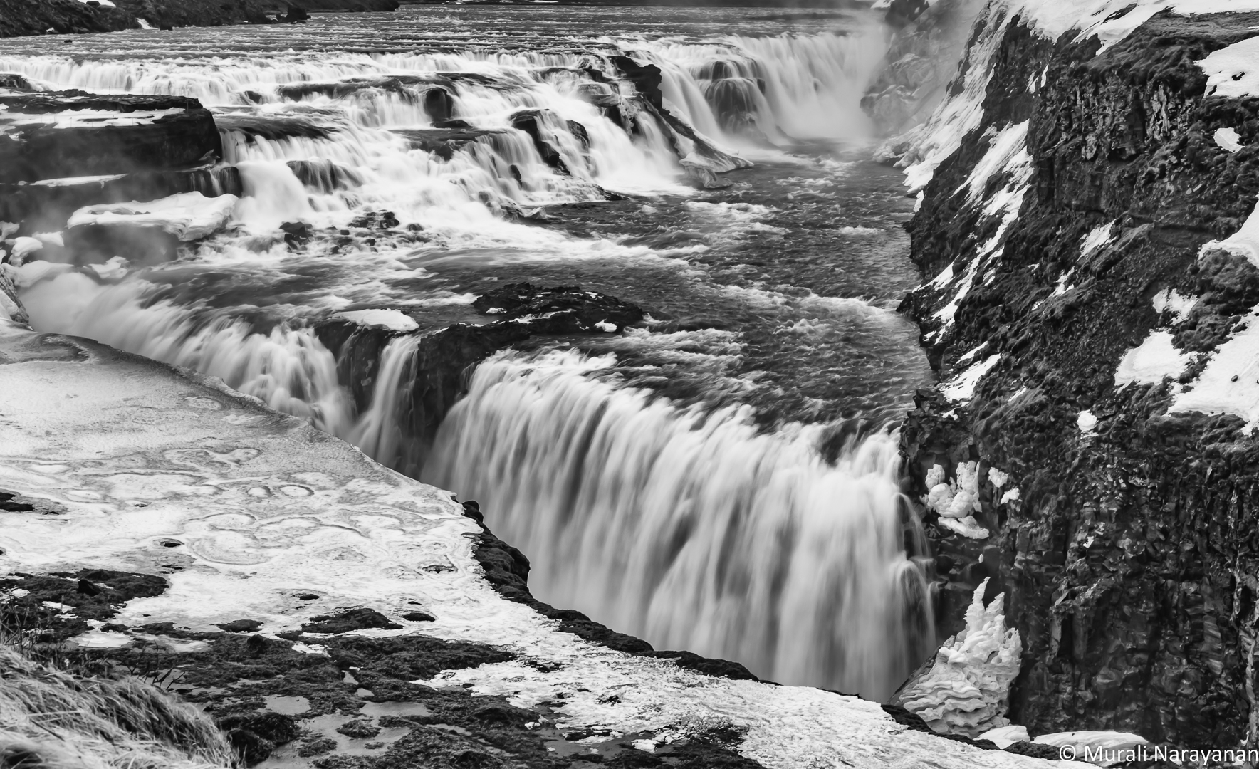
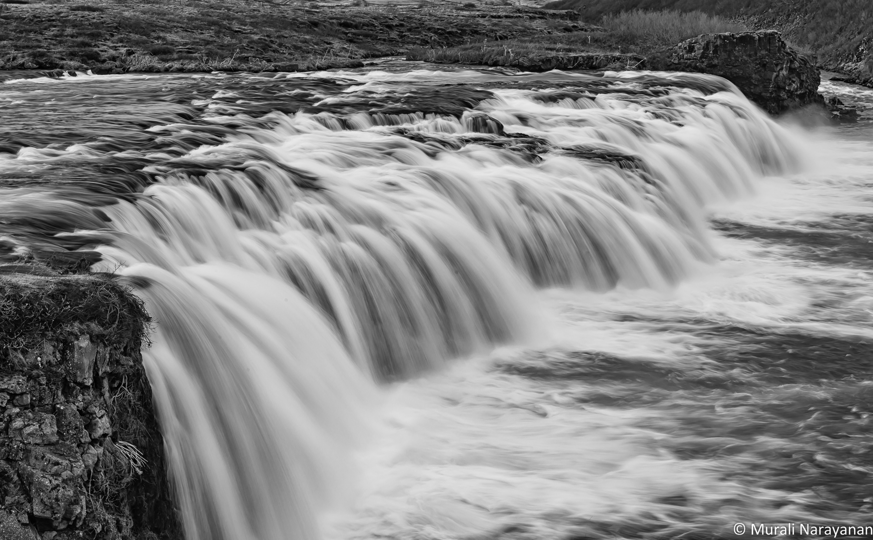
Day 6 was about following the heavily touristy Golden Circle from Gullfoss waterfall to Seljalandsfoss waterfall covering about 90 miles. Weather was slightly better but still windy and heavily clouded when we hit our first stop, Gullfoss. As a part of the trail was closed with a big warning of ice and slippery surface, we couldn’t go near this multi-stage group of waterfalls that make up the magnificent Gullfoss. We shot a few images from the parking lot.
The second stop was at the Geysir area that is a pico version of the Upper Geyser Basin of Yellowstone National Park. Strokkur, a fountain geyser, that erupts every 6-8 minutes to a hight of about 40′ is located here. We stood next to it and saw it erupt 3-4 times. We then walked around the area to see a few fumaroles emitting steam and gases before driving south to the 2nd waterfall of the day, the Faxafoss.
Although it does not measure up to the Gullfoss, Faxafoss (also called Faxi) was pretty. There was a lot of ice surrounding it limiting access somewhat. Although it is on the Golden Circle route, very few tourist buses stopped here. The ones that stopped stayed only for about 5 minutes.

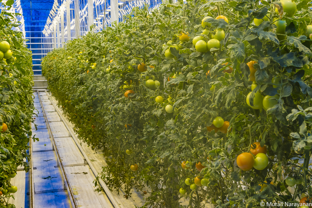
We had heard about Friðheimar greenhouse and attached restaurant and we were anticipating our visit there for a few days. It was about 10 minutes south of Faxafoss and we reached there by noon. The farm has abundant supplies of geothermal water, which provides heat to the greenhouses. The water flows enters the massive greenhouse at about 95°C. The greenhouse consumes about 100,000 tons of water per year! It is lit by artificial lighting necessary to grow the crops all year round. And photosynthesis is enhanced by using carbon dioxide produced from natural geothermal steam. The farm harvests 2 tons of tomatoes each day!!!
The restaurant is open from Noon to 4pm and serves mostly vegetarian food buffet style. We all had 4-5 servings of the tomato soup and shared a green tomato-apple pie.


The next stop was the small village of Skálholt. It was, through eight centuries, one of the most important places in Iceland. From 1056 until 1785, it was one of Iceland’s episcopal sees, making it a cultural and political center. Iceland’s first official school, Skálholtsskóli, was founded in 1056 to educate clergy. The new cathedral was built from 1956 to 1963.

After spending about 30 minutes at the Cathedral, we headed to the Urriðafoss waterfall. Although it was on the tourist route, we just saw 2 couples. It was a very good looking falls, definitely worth a visit. The government is planning to build a hydropower station on the lower part of Þjórsár river at Urriðafoss and if that happens the waterfall is expected to disappear.

We then headed to the last stop of the day, the grand Seljalandsfoss Waterfall. This is a great spot for shooting sunset but that day it was mostly raining. We just sat in the car in front of it for 15 or so minutes listening to music and just yapping. When the rain subsided, we took a quick walk to see the falls up close and shoot a few images.

We then reached our hotel (Country Hotel Anna) and checked in. Dinner was served at 730 pm and the cook prepared a vegetarian dinner for all of us. As it was raining and the AB forecast was not that good (I think the Kp index was 2), we went to bed a bit early thinking about Day 7.
March 23, 2016 (Day 7)
Day 7 Drive Map (click to view the day’s route)
Day 7 driving was relatively a short one – about 80 miles from Country Hotel Anna in Hvolsvöllur to the Farmhouse Lodge, Vik where we stayed for 2 nights.
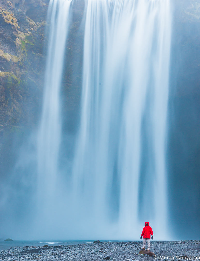
We started early at around 730 am and drove back to Seljalandsfoss Waterfall. Tip: Get to the Falls early and there is nobody and you will have the beautiful landscape just for yourself. Tourist buses don’t seem to show up before 830am especially if they are coming from Reykjavik. 2 other couples showed up for about 15 minutes.

While I was photographing, my trio of cousins took a terrific walk behind the falls and they totally enjoyed the experience. After spending about 45 minutes, we returned to Hotal Anna for breakfast. After breakfast, we shot a few pictures of the beautiful church in front of the hotel before driving eastward towards Vik.

Our first stop was rather brief at the Eyjafjallajökull Visitor Center right on Route 1. It was closed. I assume it is only open in the summer. As it was bit less cloudy, we were able to see and photograph the volcano.

Then we drove to Skógafoss and reached at around 10am. It was a zoo with a zillion tourist buses. I can’t even imagine how this place would be in the summer. Tip: Visit all major waterfalls just after sunrise when there is nobody. We spent 10 minutes, took some casual images and decided to return the next day early morning to experience it in all its glory. Below is one of the casual images taken that day and you can see the crowd behind me. Contrast this with the image taken from the same spot next day early morning in the Day 8 of this diary!!!

We hit the Solheimajokull Glacier. What a landscape? It was overwhelming. A huge number of tourists were starting on their Glacier walk. As we did not have the time, we just watched them climb for a few minutes, walked around the area and continued our drive towards Vik. Note the 3 groups of climbers in the image below. If you are interested in doing a glacier walk, you should definitely add this to your bucket list.

There is a plane wreck called Solheimasandur Plane Wreck near the Ring Road a bit east of the turnoff to the Solheimajokull Glacier but we missed it. I have seen some good pictures of it. You may want to check it out.
We reached the Farmhouse Lodge at around 1pm. Although the checkin time was 4pm, they were kind enough to dump our luggage in our rooms. We then drove to Vik for lunch. There are 2 good restaurants we tried and both were good. One was only open at 6pm and so we decided to hit Halldorskaffi. It was a cozy place but was packed including a big photography tour group. As the 4 of us are vegetarians, we had the mushroom soup and pizza. Both were excellent. I highly recommend the place and in fact, we stopped here on March 28 (Day 12) on our way back from Hofn to Keflavik.
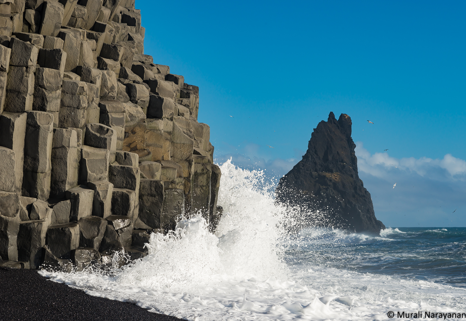
After a good lunch, we walked around the Vik Church (yes, it was also locked) and then drove to Reynisfjara (a black sand beach) to see the basalt columns and Reynisdrangar sea stacks. Both were just amazing.
WARNING: The waves at Reynisfjara are especially strong and unpredictable, and fatal accidents have occurred at this beach, so people are advised to take extra care when visiting the area. In Feb 2016, a man was swept out to the ocean. If I had known this, I wouldn’t have taken the first image below!!!

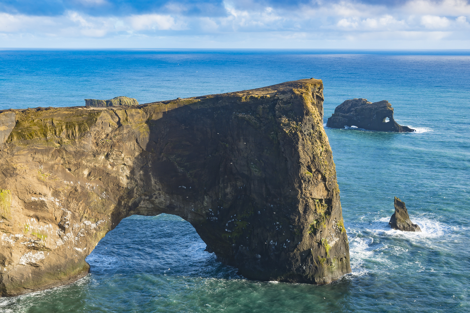
The next stop was Dyrhólaey (formerly known as “Cape Portland”). It was formerly an island of volcanic origin.The view from up there is majestic: To the north is to be seen the massive Mýrdalsjökull glacier. To the east, you can see black lava columns of the Reynisdrangar and the Reynisfjara black sand beach. In front (facing south), there is a gigantic black arch of lava standing in the sea, which gave the peninsula its name (meaning: the hill-island with the door-hole). When we were there just before sunset, huge waves were thrashing the shoreline and once in a while for a second or so, you could see a rainbow.

On our way back to our guesthouse, we took a small pit stop at the Reyniskirkja church. As it was locked, we couldn’t go inside but the view from the outside was just amazing.

No Aurora Boralis tonight as it was very cloudy, the Kp index was just a 1 and we were too tired to drive around chasing one. Bala cooked dinner in the Guesthouse kitchen and we all had a good meal. The two managers of the guesthouse were super helpful and friendly. They washed our clothes, dried, and folded them. Huge thanks to them. Wi-Fi was quite fast as well. We did some emails, planned the activities for Day 8 and went to bed at around 1030pm.
March 24, 2016 (Day 8)
Day 8 was relatively a slow day as it was mostly raining and howling winds. We got up early and drove to Skógafoss. Luckily, we were the first ones to show up. 2 more cars showed by about 15 minutes later. 6-7 people shared the whole area for about 45 minutes and it was awesome. Tip: If you want to enjoy the popular falls without the crowd, go there bright and early. That means 7am in March. Here are 2 images from the falls.

My 3 cousins climbed up to the top but they were not terribly impressed with the view. YMMV. I helped out a gal from Australia who was doing a photo shoot for an ironing board company. She has been travelling all over Iceland photographing an ironing board in front of various falls!!! Looks like a real fun job!!!
We returned to the Lodge for a very relaxing & slow breakfast. After breakfast, we drove up to Heiðarvatn, a lake nearby. The weather was brutal – cold and very high winds. We didn’t even venture out to get out of the car. I shot an image from inside the car using my iPhone.

About 45 minutes later, the wind subsided and the the sky started to clear a bit. Then took another shot.
Went to the grill attached to the N1 gas station for lunch. The bistro & pub next door was closed. I was surprised to find 3-4 vegetarian items on the menu including a veggie burger. We had a good and relaxing lunch. We returned to the Lodge after lunch. We returned to Vik in the late afternoon and went to the black sand beach behind the N1 gas station. Wow, was it windy. The black sand was hitting our faces like razor blades. I took one image of the Reynisdrangar.

The Vik Church (Víkurkirkja) was lit and as it was blue hour (15 minutes after sunset), contrast between the church and the mountain and sky behind it was striking. I took a few photographs.
We had an excellent dinner at Sudur Vik. The restaurant opens at 6pm during late winter and I recommend you get there before 7pm. We were there at about 630pm and it was 50% full. When we finished dinner and came out at about 745pm, there was a huge line.
Due to cloudy weather and rain, Aurora Borealis that night was out of the question. Went to bed early with anticipation of visiting Jokulsarlon on Day 9.
March 25, 2016 (Day 9)
Day 9 Route Map (Vik to Jökulsárlón)
Today, we drove from Vik to Jökulsárlón where we stayed at the Kálfafellsstadur Bed & Breakfast which is located on the Ring Road, 15 minute drive east of Jökulsárlón.
We had early breakfast and loaded the car and left Vik at around 8am. A few miles east of Vik, we came across a massive field of mossy lava rocks that was impressive. We stopped at a safe spot on the side of the road and took a few pictures.

We also came across a lot of unnamed waterfalls behind farm houses. I wish I could buy one of these houses and move in!!! One was a pair of falls behind a house that we really liked. Below is an image of it. Note the 2 hikers on the top of the falls 🙂

The next stop was at a less known but impressive waterfall called Stjórnarfoss. It was on a road off of the Ring Road with an easy access to the base. There was nobody at the falls when we were there.
After spending about 30 minutes, we continued the journey towards Jökulsárlón and stopped at the next waterfall, Foss a Sidu. We parked the car on a side road in front of the falls and had our lunch consisting of Icelandic yogurt, fruits, and protein bars enjoying the falls and the surrounding scenery.

After lunch, we checked out the Dverghamrar basalt columns opposite to Foss a Sidu. These are peculiar and beautiful formations of columnar basalt. The landscape is thought to have been molded at the end of the Ice Age. The sea level was higher at that time and it is believed that the waves caused the peculiar look of the rocks. Columnar basalt is formed when lava flow gets cooled and contraction forces build up. Cracks then form horizontally and the extensive fracture network that develops results in the six sided formation of the columns.

A few miles east of the basalt columns, we came across a amazing group of small waterfalls right next to the road. We had never heard about this spot while researching for the trip. After our return, I pinged an amazing nature photographer, E.J. Peiker asking him for the name of the falls. Checkout his amazing images of Iceland on his website. He said the name of the falls is Fossálarfoss. Don’t miss this not-so-famous beauty.


The next stop was at a road side view point of Hafrafell mountain & Svínafellsjökull glacier. Due to time constraints, we had to skip the visit to Skaftafell and Svertifoss. Will hit these spots on the next trip 🙂

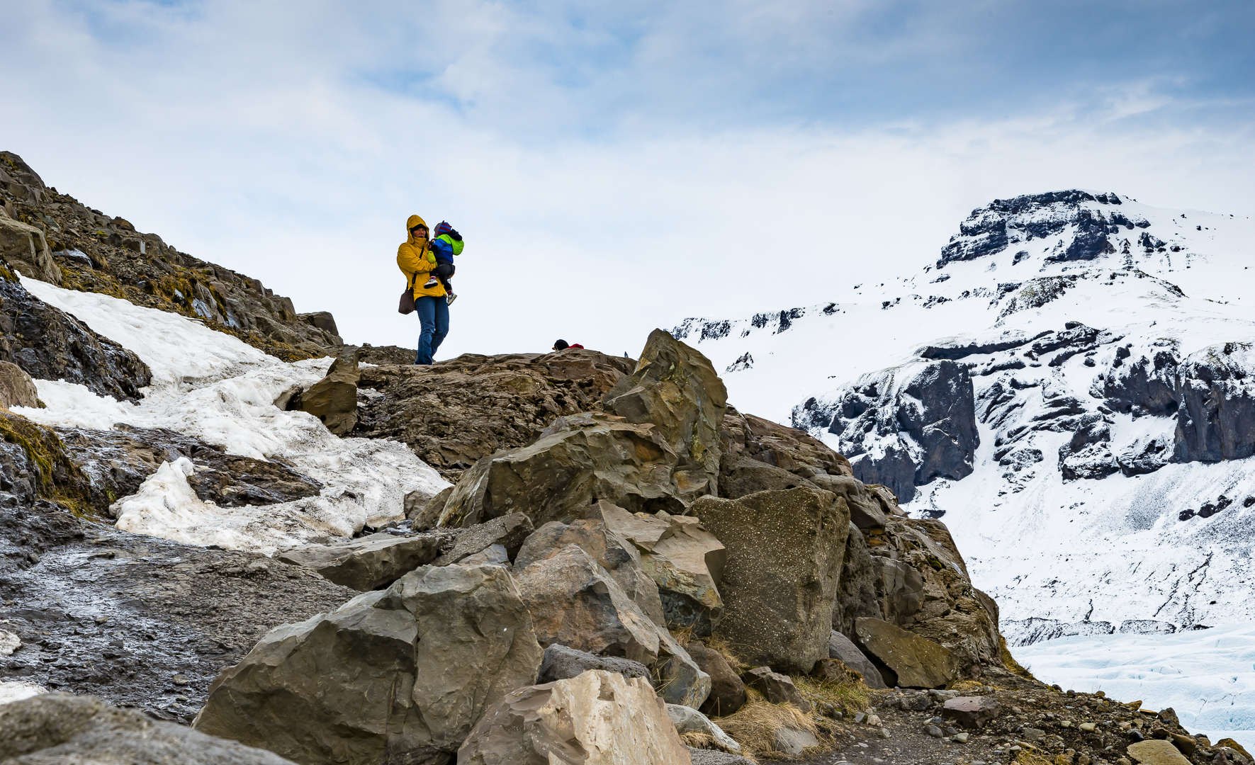
We spent an hour walking along the Svínafellsjökull and the scenery was mind boggling. We were impressed with a woman hiking carrying her child..

From Svínafellsjökull we drove to Kálfafellsstadur Bed & Breakfast after a short stop at Jökulsárlón. The B&B did not meet our expectations. Although the manager/host was super helpful, when we reached there we found out that it was not a B&B but only a B (Bed only) :-(. No breakfast, lunch, or dinner. It is only a B&B in the summer season. Luckily we had some cereal, milk, and bananas that we had picked up 3 days ago. The host was gracious enough to allow us to cook and Bala used his ingenuity to whip up an Italian Risotto for dinner. The internet was also pretty pathetic. It is hard for me to recommend this place but considering choices around Jökulsárlón are rather limited, it can be okay. Tip: If you decide to stay here, get a room on the ground floor else you will have to climb up narrow stairs with your luggage. Parking is also rather limited.
March 26, 2016 (Day 10)
We spent Day 10 in and around Jökulsárlón. After breakfast, we left the Bed (and no breakfast 🙂 ), to the Diamond Beach. On the way, there were some interesting spots to explore. The first was a few puddles of water reflecting the nearby mountains. Most of the puddles were frozen but 2 were rather clear.

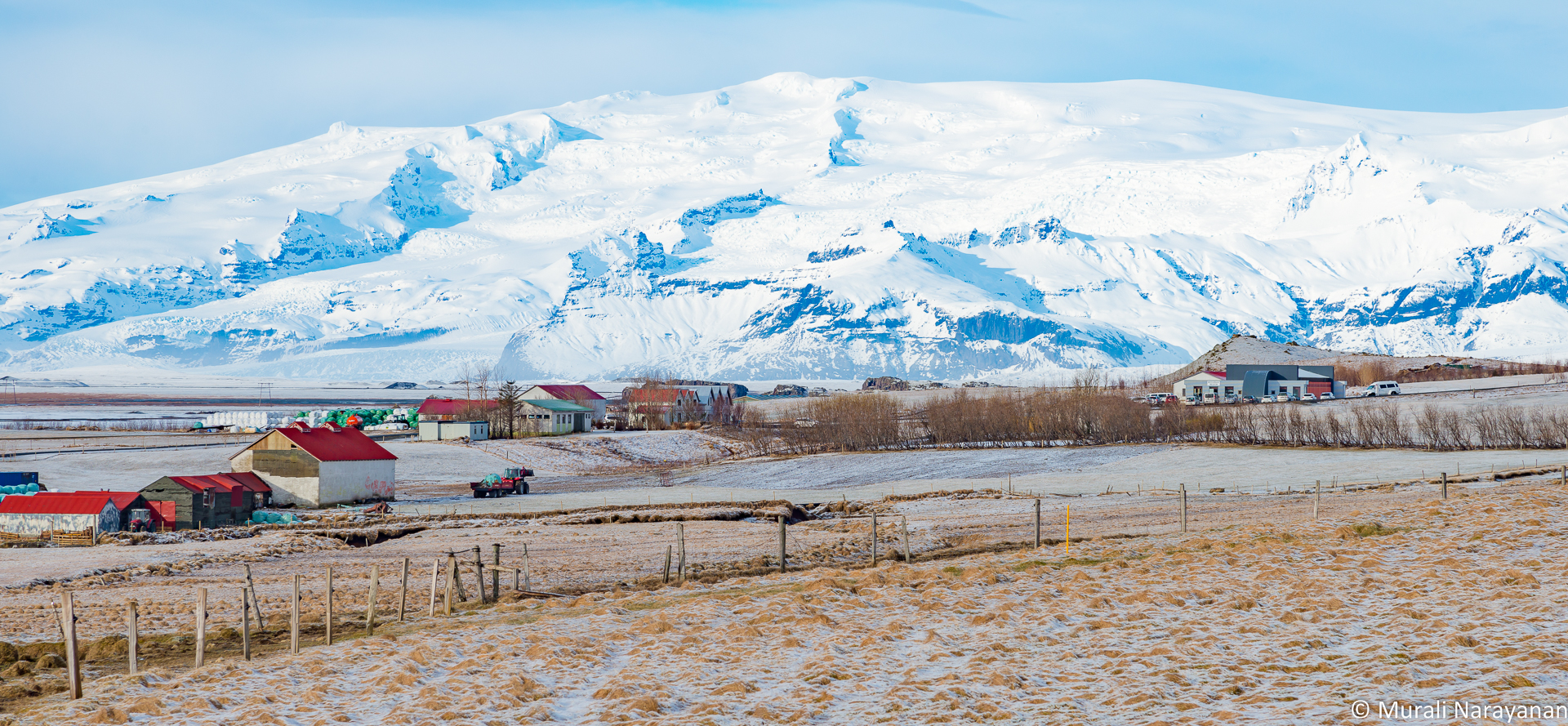
Just before reaching the Diamond Beach, we came across a beautiful farm with the Breiðamerkurjökull glacier as a backdrop. We couldn’t resist stopping to view and photograph the scene.
The next unplanned stop was at the mossy lava field along the Ring Road. We hiked a bit to view the surrounding scenery.
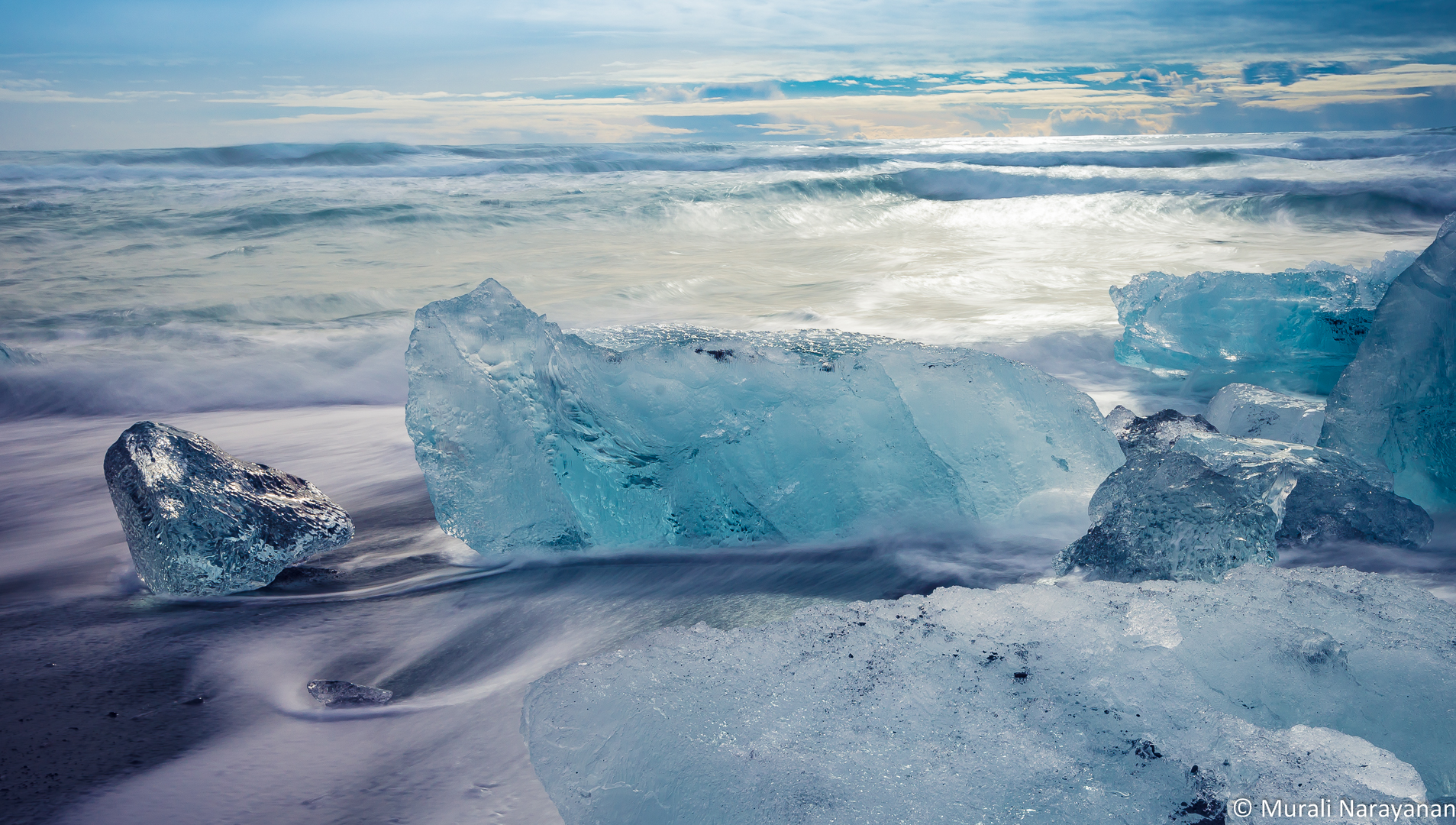
After some good exercise walking on the lave mounds, we headed to the famous Diamond Beach (it is called the Breiðamerkursandur in Iceland; try pronouncing that!!!). Each day new icebergs are washed up on the black volcanic sand. They come in all sorts of shapes and sizes, big and small. While we were there, it was quite difficult to walk as there were too many of them all over the beach and waves hitting them constantly. Here is a picture of me at the Diamond Beach. The whole experience was surreal and I had never seen a place like this anywhere. I consider this as one of the top 3 spots in Iceland we visited.

We then drove to the Lagoon and walked around for an hour or so.


We then had Icelandic Yogurt and granola bars for lunch at the Cafe next to the Lagoon. Then we walked along the shore of the Lagoon for another 1-2 hours. Here are some images from the walk.

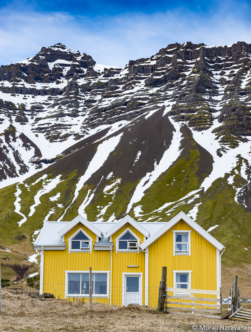
After having spent 5 hours at the Lagoon, we decided to drive back to the Bed & No Breakfast. On the way, we saw the beautiful yellow building of the Hali Country Hotel, its back facing a lake and the Atlantic Ocean.

No Aurora Borealis that night as it was very cloudy. After 10 nights (11 for my 3 cousins), we saw a mediocre AB in Grundarfjörður and slightly a better one in Gullfoss. We had 2 more nights in Iceland before we flew back to our respective countries (US, India, and Singapore). and we started praying that the AB Gods would be very considerate. Did they deliver? See the page for Day 11 (Höfn).
March 27, 2016 (Day 11)
We spent the Day 11 in and around the coastal town of Höfn. We left the Kálfafellsstadur Bed & No Breakfast (as I stated in the Day 9 blog, the B&B serves B only in the summer) for Höfn, a short drive. On the way, we found a small but beautiful unnamed waterfall behind an unoccupied farmhouse. Here are the pictures of the the farmhouse and the small waterfall behind it.

We reached Seljavellir Guesthouse just outside of Höfn at around 10am. The super inn keeper allowed us to check-in right away. The rooms were excellent and very modern. The bathroom floors were heated. The showers were top notch. This was THE BEST hotel/guesthouse we had stayed during the 12 days. Excellent service, super friendly and helpful hosts, very fast Wi-Fi, and modern and clean rooms with floor to ceiling glass for terrific views of the mountains. Tip: Get a room in the back for great views of the mountains and to experience the Northern Lights right from your bed.
We dumped our stuff and drove to the town and checkout the views. Then we decided to drive to Stokksnes to view the lighthouse and the rocky cliffs. We had to pay US$8/person to the owner of the cafe/pub at the entrance to the road to the lighthouse. When we reached the lighthouse, it was so windy, we had to turn the car around so that when opened, the doors wouldn’t fly away. I couldn’t stabilize my not so light carbon fiber tripod either. You could feel the power of the Atlantic Ocean as the waves hit the rocky shore with massive force. The black sand was hitting my face so hard that we could barely see the Vestrahorn mountain. May be that is God’s way of saying that we should visit the place another time 🙂

One the way back, my cousins located very skittish group of 3 reindeer. The wind also died down quite a bit. We decided to quietly follow the reindeer to take a good shot. We then parked the car at a spot and waited for the reindeer to come close-by. After about 45 minutes, one of them came about 50′ feet from us. Got a good shot of it staring at us.

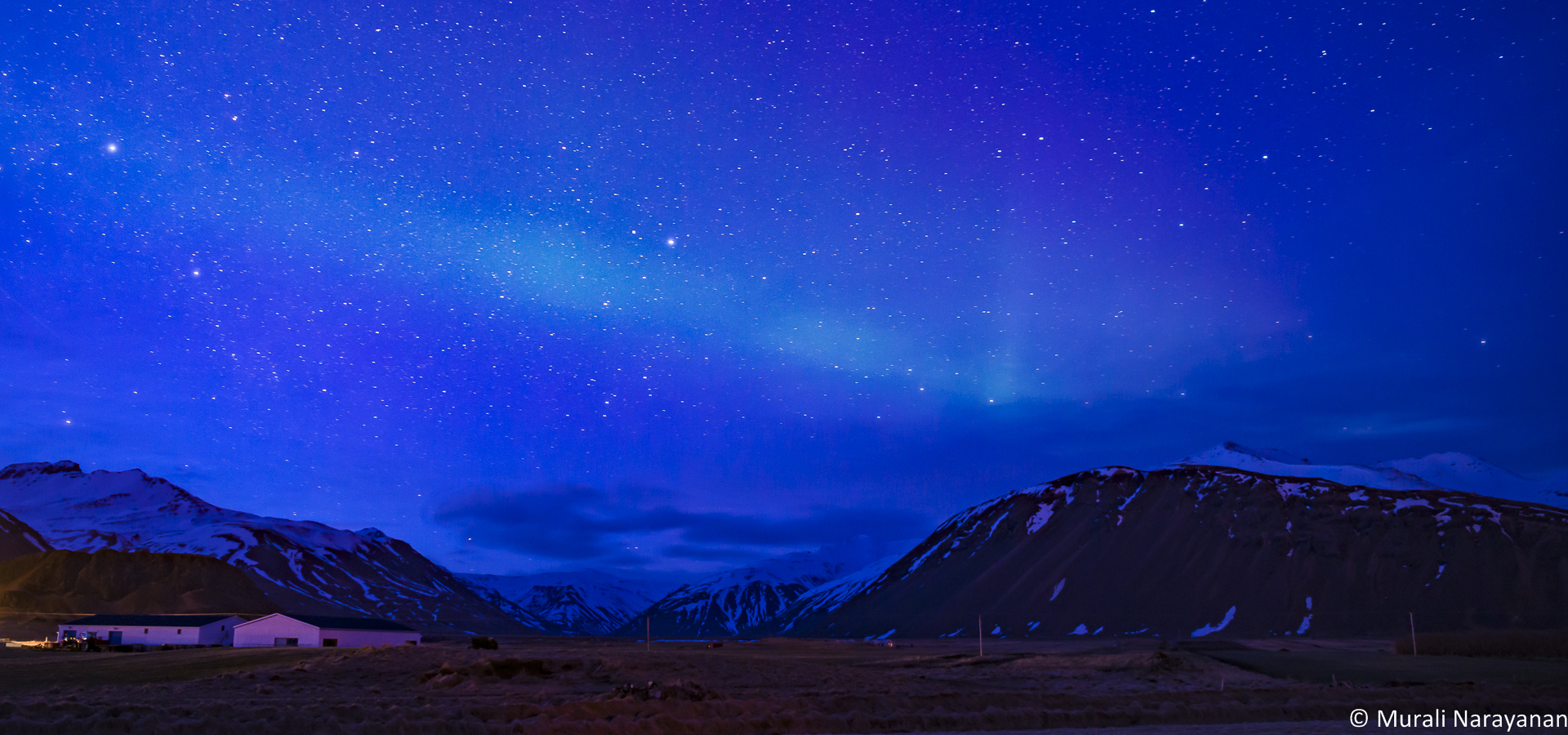
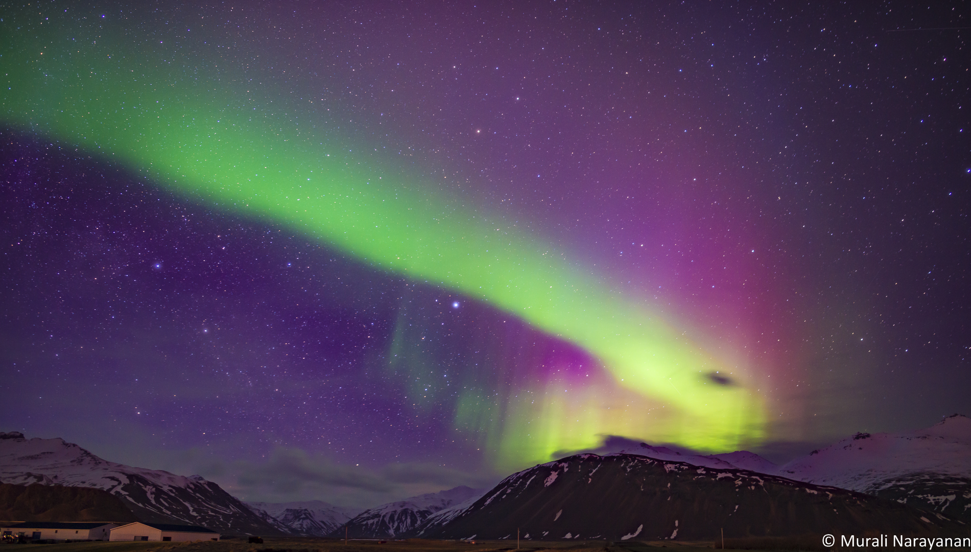
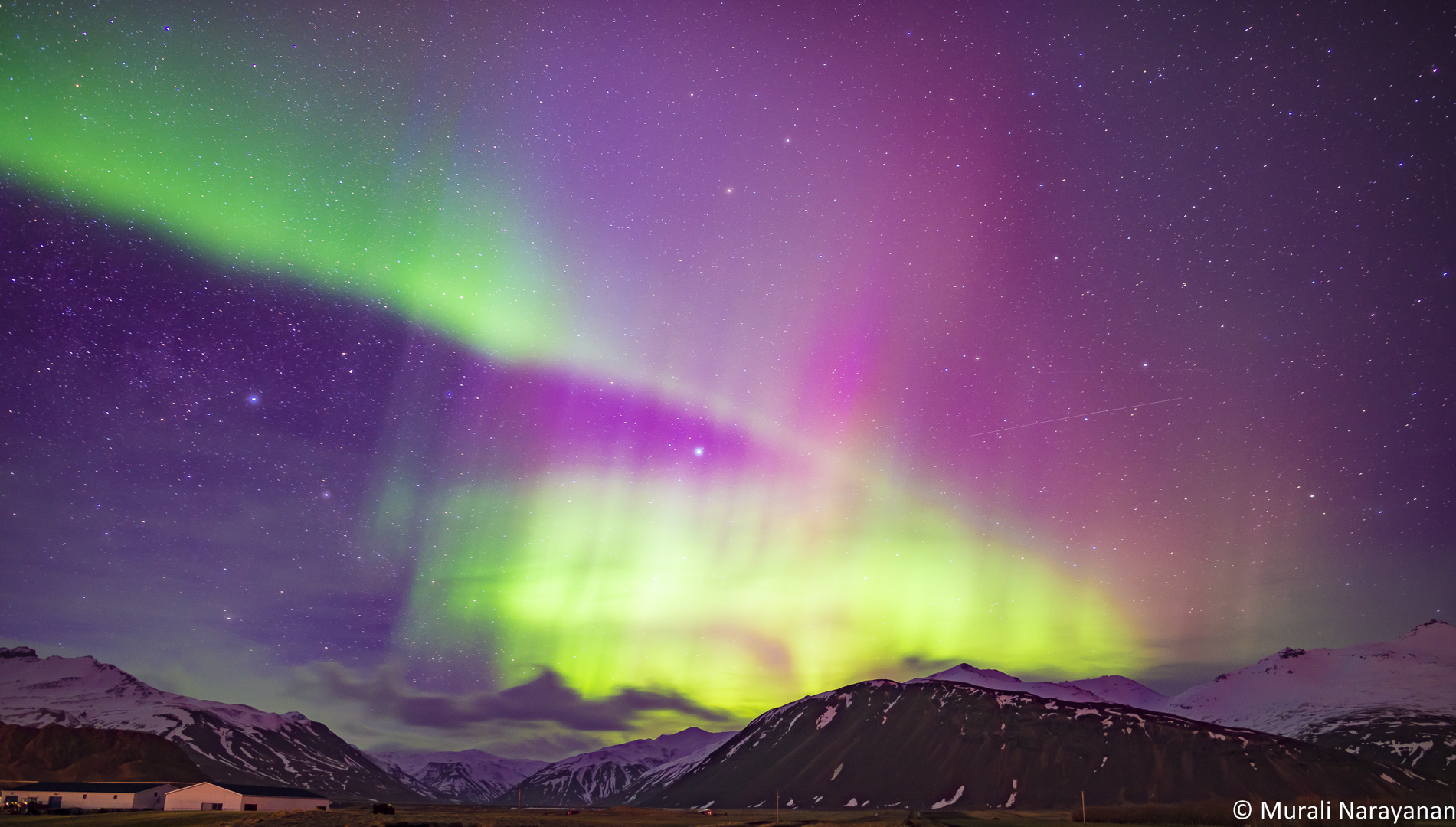
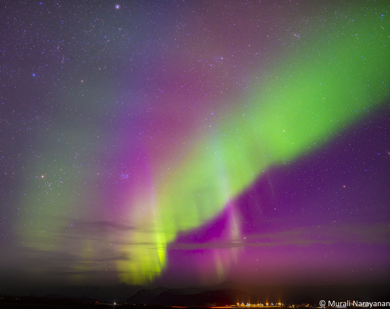
That day was Easter. That meant almost everything was closed. Luckily Kaffi Hornið was open. We had a terrific Italian dinner. Highly recommend the place. Super helpful staff. After dinner, we returned to the Guesthouse at around 730pm and checked the weather forecast. The Aurora Borealis (AB) forecast was promising. At 9pm, Kp index was expected to be a 4. The clouds were moving away and sky looking towards the west and north was getting clearer. At 930 (about 45 minutes after sunset), I setup my Nikon D800e with the 24mm f1.4 Rokinon lens on the tripod right in front of our room and shot a few images across the sky every 3 minutes or so. The shutter speed for each image was between 15 and 25 seconds at ISO between 800 and 1000. After the 5th shot taken at 946pm, the LCD screen showed a very dim green band. Naked eyes saw just the stars and a blue sky. Over the next 5 minutes the band became bigger and brighter and the sky became darker and we could start to see it with our eyes. By 10pm, the grand show had begun and lasted for about 90 minutes. The host walked around notifying the guests that the show has started. I shot an image every 1-2 minutes until 1116pm for a total of 53 images. Below is the sequence of 10 images shot between 946pm and 1116pm. What a show. The AB Gods finally delivered on 11th night!!!


All went to bed super satisfied and thinking about the long drive back next morning to Keflavik International Airport to fly back home.
March 28, 2016 (Day 12)
The 12th day was devoted to drive about 300 miles from the Seljavellir Guesthouse just outside the town of Höfn to Hotel Berg near the Keflavik International Airport. No more major landmarks or Icelandic horses to see and photograph. Almost all spots on our plan were hit. A few that were missed have been moved to the next visit’s list. We stopped at Vik for lunch and to shoot some interesting scenes along the route. Here are some images from the segment of the trip.


We reached Hotel Berg is Keflavik right as planned at around 630pm. The hotel is located right on the water next to a marina. Found out that they start serving breakfast at 3am to meet the needs of guests who have an early flight out of KEF. We drove to an unnamed lighthouse quite near to the hotel on Strandleiðin.
Then had dinner at Thai Keflavik. They can prepare most of the dishes for vegetarians. We shared a Tom Yam Goong soup and Green curry. Both food and service were excellent. Price was reasonable as well. Exterior of the restaurant is not impressive but interior decor was comparable to a mid range Thai restaurant in the US.
We were a bit greedy after a spectacular Auroa Borealis experience the previous night. We drove up to Gardur Lighthouse at around 9pm but there was too much light pollution around it and it was too cloudy. We stopped on our way back at a spot where there was very little light pollution but unfortunately didnt see any Northern Lights. We returned to the hotel at around 1030pm, repacked the luggage to get back to reality the next morning. My cousins flights were at 7am while mine to Seattle was only at 5pm.
In the last page of the blog (Day 13), I will post some images I took before dropping off the rental car, rental car return experience (one you must read), and some trivia around the whole trip.
March 29, 2016 (Day 13)
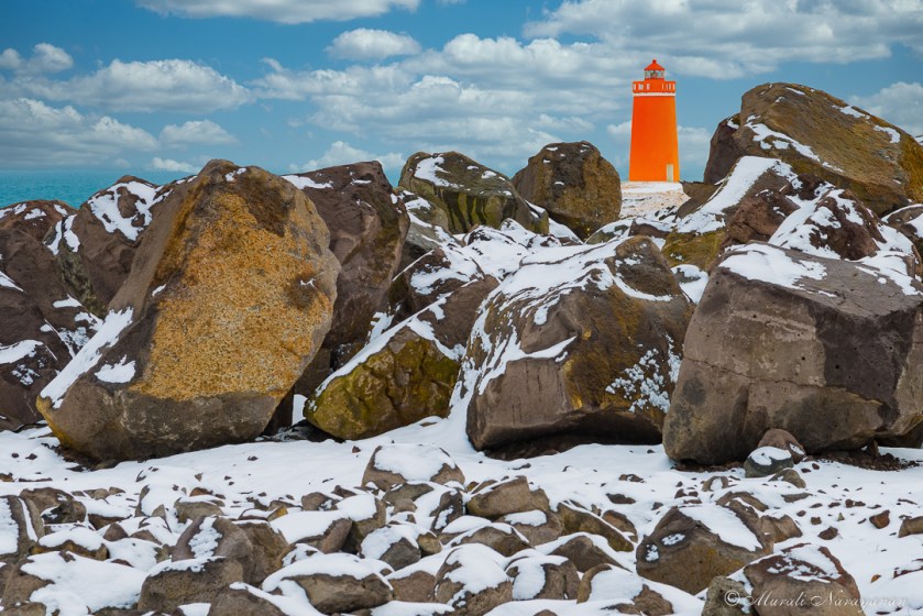
Reality started hitting all of us when we woke up. My 3 cousins left for KEF airport in a hotel shuttle bus at 5am to catch the 730am flight to Singapore & Bengaluru, India respectively. My flight was not until 5pm. The hotel manager was very kind enough to allow me to check out at 1pm. I had a rather late breakfast and at around 10am drove around Gardur and Keflavik/Reykjanesbær to look for some interesting spots. It had snowed the previous night and there was snow everywhere. On Day 2, we had been to the lighthouse near the hotel that was surrounded by black lava rocks. I decided to go back and see if there were any interesting photo ops. Yes, there was as shown by the image below.
Located a good looking church in Gardur but it was closed. Shot a picture of it from outside.

I returned to the hotel at Noon, packed up all the luggage and loaded into the Jeep and went to the Reykjanesbær City Center for lunch at a Subway restaurant. The sub was 40% more expensive than in the US, it tasted pretty much the same as in the US. Then refuled the Jeep and returned the vehicle to the Greenmotion (aka Iceland 4×4) rental car facility. Now the fun began.
The guy takes the keys and walks straight to the front of the vehicle and tells me that there are 3 minor scratches on the hood. The vehicle had about 120K miles when we picked up and it was pretty beat up already with scratches all over the body.We never noticed the scratches on the hood until we returned it. Here is the image of the scratches captured by my iPhone6.

We had taken full insurance when we booked the vehicle via rentalcars.com. He tried to identify other problems but luckily we had noted these at the time of the pickup. A few minutes later he returned and asked me to pay 290,000ISK (about US$2400) to repair the 3 scratches on a beat up Jeep that had about 100x scratches everywhere. I had no choice as I had to catch a flight back to the US. I paid, got the necessary paperwork, and left for the airport with a little bit bitter taste of the rental car experience. I was not 100% sure if rentalcar.com will refund the charges.
About 10 days ago, I got an email from Greenmotion that they will be refunding me about $1465 as the cost to fix the 3 scratches was only US$935. We submitted the charges to rentalcars.com and they promptly refunded $935 and credited it our credit card. We were relieved.
Here is the moral of the story for renting cars in Iceland:
- Rent a car from a reputable agency after doing reserach on the web. If you do a Google or Bing search, you will see a lot of horror stories about Green Motion and even Keflavik Hertz. Don’t expect Hertz US to bail you out.
- Get full insurance coverage. Don’t be penny wise and pound foolish. The Ring Road is well paved but some side roads are not. Also roads like Route 42 is mostly gravel. The rough sand and small pebbles will scratch your vehicle. Get the maximum coverage or you will end up paying more for the “damage” charges than for the rental car.
- Completely checkout the car at pick up time. Document EVERY issue how ever minor it is including squeaks of the doors, break noises, scratches on head lights, glass, etc before you leave the rental car facility. I have lived in the US for 40+ years and rent on the average 10-15 times/year. At no time, anybody has checked the car when I returned. I don’t even get a receipt as it gets emailed by email address. Europe is different and I have learned a lesson.
Allz well that ends well!!! Cant wait to return to Iceland again!!! A terrific country but rental car management needs improvement.
Other Iceland travel trivia:
- For 13 days, rental car cost US$1900; Gas US$466; Lodging: US$3062; Food: $826; Other expenses like SIM Cards, Aurora Borealis tour in Reykjavik etc: US$350. 4 people shared the expenses. Cost/person = US$1650. Not bad at all.
- We drove 1575 miles on the trip. Jeep Grand Cherokee consumed 20 mpg with full load almost all the time.
- Driving is very easy in Iceland. It is super difficult to get lost. We didn’t see one traffic light for over a week after we left Reykjavik. Lots of roundabouts though. I don’t recollect seeing a 2-lane road outside Reykjavik.
- Cell phone service works fine on most roads along the coast. We used SIMInn service. Prepaid data cost $15/GB. You can pick up the SIM cards at the KEF airport.
- During the 13 days, we never saw one cop!!! We first noticed it a week into the trip. After that we were watchful and on the lookout for a cop but never saw one. We saw 4 security guys with machine guns during checkin at KEF on our way back.
- There are very few grocery stores in the country and especially outside of Reykjavik. Load up when you find one. Plus the opening hours are highly limited. Some are only open from 11am to 6pm (thats when you will be doing sightseeing).
- All the 4 of us are vegetarians and we had no issues.
- We had to remove our shoes/boots before entering hotels and guesthouses outside Reykjavik and Keflavik. This reminded of our homes 🙂
- Beautiful Aurora Borealis is not common. You need a clear sky, no light pollution, good AB forecast (Kp index of 3 or higher). If you must see one, plan to spend 2 weeks unless you are lucky.
- Hotel & guesthouse staff are very friendly and speak excellent English (better than my Icelandic 🙂 ). Breakfast is not fancy but good. Unless you stay in a 5-star hotel, don’t expect somebody to make you an omelet on demand.
- In Keflavik and Reykjavik, you can smell the sulphur in the water when you shower. I really started liking it and I miss it a lot back home in Seattle!!!
- Snæfellsnes peninsula was stunning but we rarely saw a tourist. Not sure why.
- It is a very windy country. Holding a tripod steady is no fun when the temperature is close to freezing and wind blowing at 40-50 mph. If you don’t like the weather, wait for 15 minutes. We saw sunshine to fog to rain to snow all within 1 hour.
- There are waterfalls everywhere. Having a waterfall in your backyard is real cool!!!

One response to “Iceland – March 2016”
Loved reading the blog – only issue is I feel I have visited Iceland already 😝
Looking forward to our trip, and following the route you took
LikeLike