Earlier this week, we decided to visit Hoh Rainforest located in the western side of the Olympic National Park and the tide pools at Ruby Beach on the Pacific coast. The weather forecast was mostly cloudy, good to photograph both.
Hoh Rainforest
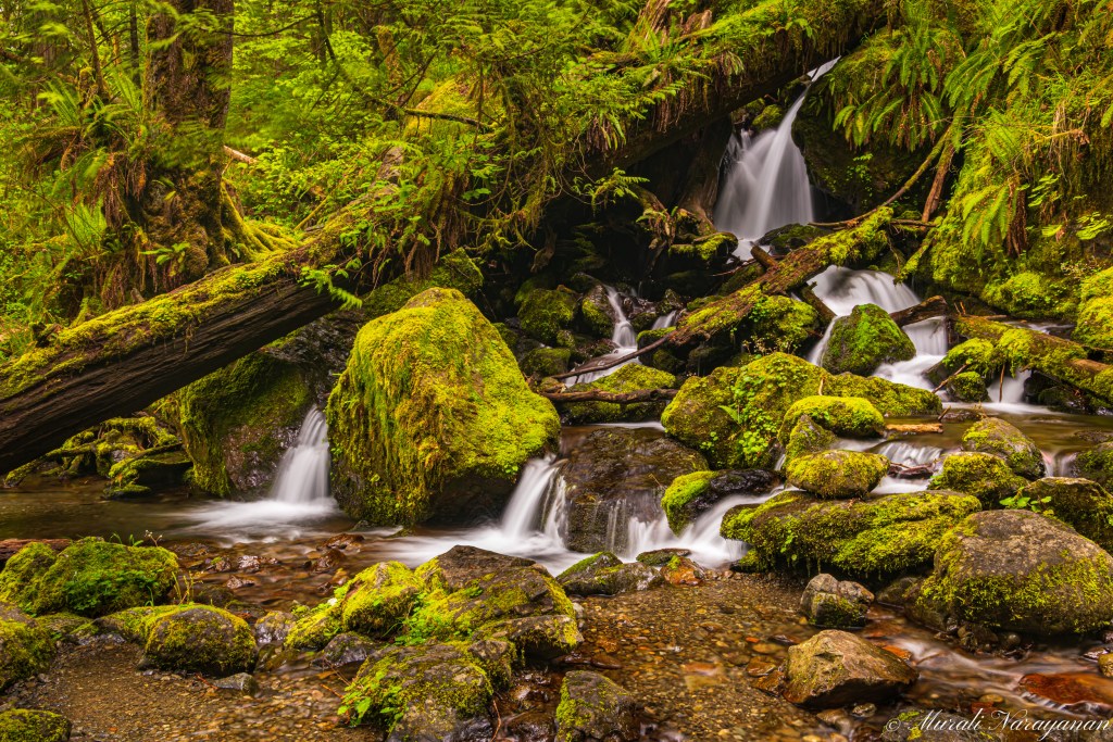
We left home at 0930 on Tue and after a lunch break in the Quinault Rainforest, reached Hoh Rainforest Visitor Center at 1500. Photo tip: At about 2 miles from the US101-Upper Hoh Road intersection, there is a cute creek worth photographing in the early spring when the snow melt peaks. Water flow was considerably reduced when I stopped here this time.
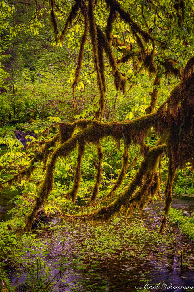
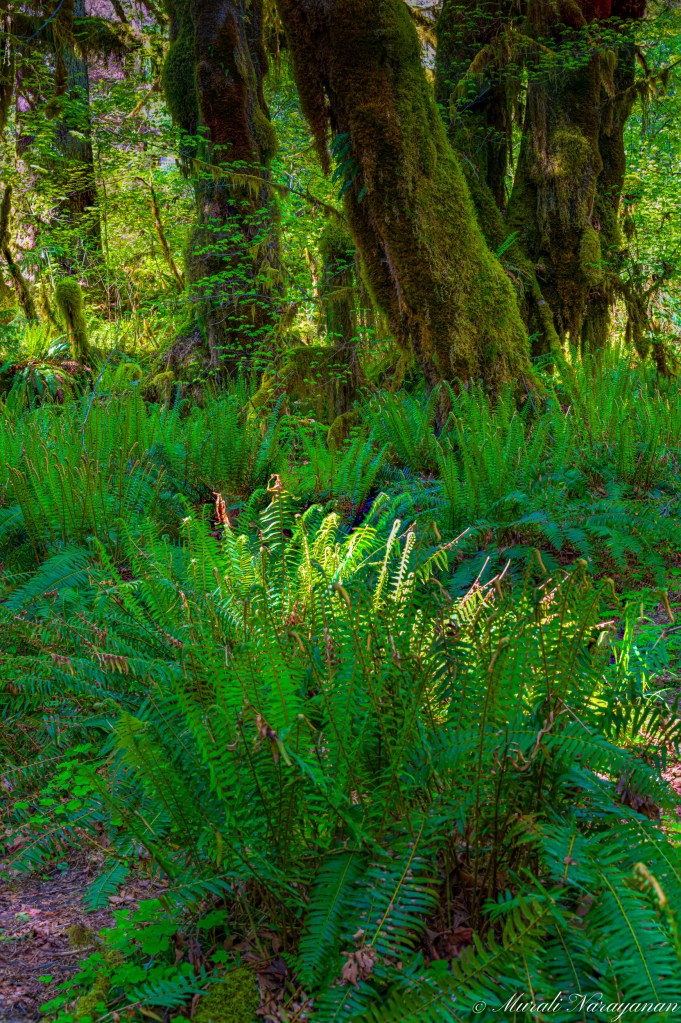
Hoh is one of the five or so temperate rainforests in the world. Throughout the winter season, rain falls frequently, contributing to the yearly average of 140″ of precipitation. The result is a lush, green canopy of both coniferous and deciduous species. Mosses and ferns that blanket the surfaces add another dimension to the enchantment of Hoh. What is special about the rainforest is that trees there may be more than thousand years old, and every tree is covered with its own plant life. This fact makes it an individual small microcosm. The most predominant species are Sitka Spruce, Coast Douglas-fir, Western Redcedar, Vine Maple, Red Alder and Black Cottonwood.
Unless you want to camp overnight, the best way to experience Hoh is to hike one of the two trails – 0.75 mile Hall of Mosses Trail or the 1.25 mil Spruce Trail. We decided to walk the Hall of Mosses trail. It is mostly flat except for a short ascent near the beginning. Photo tip: Do the hike just after sunrise on a cloudy day. There will be considerably less crowd. As we started the hike at around 1515, it was quite crowded. We completed the hike in an hour. I always find photographing the amazing natural beauty of Hoh extremely difficult as there are no iconic spots like a waterfall to anchor the image. You have to look for patterns and/or leading lines to get a decent composition. Also, during the hike, it was partly sunny and the light was harsh to capture some shots. This is a place you have to push yourself to capture a killer image.

Nikon D810 70mm f8 0.4sec ISO64
Nikon D810 70mm f10 0.8sec ISO64
Nikon D810 70mm f11 1/4sec ISO 64

Nikon D810 82mm f11 0.4sec ISO64
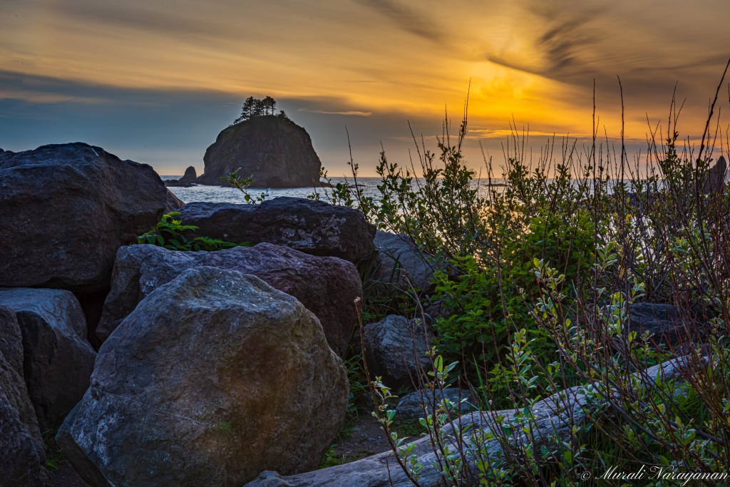
La Push First Beach
La Push is a small unincorporated community situated at the mouth of the Quillayute River in the northwest side of Washington State. It is the largest community within the Quileute Indian Reservation, which is home to the federally recognized Quileute tribe. The community has historically been located on the coast, however sea level rise led the community to begin managed retreat to higher grounds in 2017.
La Push is home to four terrific beaches with great views of anumber of sea stacks. The Second Beach is considered the best in the area but requires a mile hike through a rainforest from the trailhead/parking lot. You will also need headlamps to find your way back to the car after sunset. As we were not prepared for a hike in the dark, our choice was between Rialto Beach and the First Beach.
We left Hoh at around 1700 and checked into our motel in the town of Forks 45 minutes later. After having some snacks, we decided to go to the First Beach, within the Quileute Indian Reservation. We reached the beach at 1900 and parked the car at a gravel land opposite to the tribal school. We had 2 hrs to walk around as the sunset was at 2100. We saw some folks surfing and others swimming in the calm but cold water. Due to a thin layer of clouds, the sunset colors were okay but not spectacular. I captured a few good images. Although visiting La Push was not in the original itinerary, it was worth the time spent there.
Nikon D810 55mm f16 1/60 sec ISO 64

Nikon 810 48mm f16 1/200sec ISO 1600
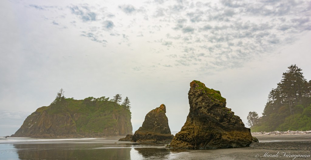
Ruby Beach
Ruby Beach is the northernmost of the southern beaches in the coastal section of Olympic National Park in Washington State. It is located on Highway 101, about 25 miles south of Forks. Like virtually all beaches on the northern coast, Ruby Beach has a tremendous amount of driftwood. It is notable for the number of sea stacks and tide pools. The beach is so called because of the ruby-like crystals in the beach sand.
After an early breakfast, we left the hotel at 0645 and reached the beach parking lot 30 minutes after. It was a short hike – 0.25 miles with an elevation loss of just about 100 feet. There were huge number of driftwood that we had to navigate to get to the sand. Low tide was at 0830 and so we had plenty of time to look for tide pools.
We intially walked north towards Abbey Island and we had to cross a creek to get to a tide pool. We had to wade in the water flowing at a high speed to cross the creek. We just found one sea star. On our way back, another photographer suggested we walk south to see better tide pools. We crossed the creek once more and located an excellent tide pool. Along the way, I took a few shots of the sea stacks and Abbey Island. As it was overcast, the pictures of the sea stacks were below my expectations.
Nikon D750 26mm f22 3sec ISO 100

Nikon D750 16mm f16 1/8sec ISO 100
We saw a few sea stars and lots of mussels, barnacles and anemones. I have been searching for a red sea star for twelve years and I didn’t succeed on this visit either. The quest continues.

Nikon D810 120mm f16 1/2sec ISO 64

Nikon D810 90mm f11 1/3sec ISO 64
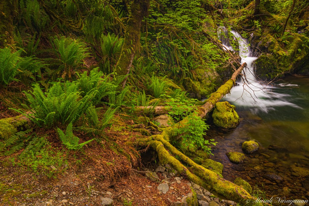
Quinault Rainforest
Quinault is my favorite rainforest in Washington State. Althugh not as famous and popular as its neighbor, Hoh, it is serene with lots of small but beautiful waterfalls. It is also less visited. There are two other blog posts on this site about Quinault rainforest worth reading.
The original plan was to just have lunch in the rainforest and drive home but the weather was perfect for waterfalls photography. We left Ruby Beach at 1015 and reached Quinault Rainforest at 1130. Our first stop was at the Falls Creek campground. Best spot to photograph the Falls Creek Falls is from Campsite #20. I got a few good shots here.
Nikon D810 28mm f11 0.8sec ISO 64
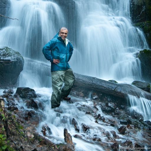
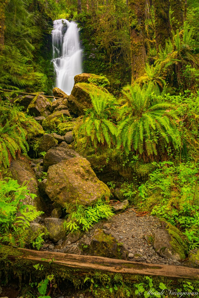
The next stop was to the Merriman Falls, the best waterfall within the area. We had planned to have lunch at the falls. When we arrived at 1230, there was nobody at the falls. We ate lunch and I spent a little bit over an hour capturing images and a video.
iPhone 12 Mini
Nikon D810 24mm f16 1.6sec ISO 64
Nikon D810 28mm f13 2sec ISO 64
Around 1400, we left the falls to hit the last photo stop of the trip, Bunch Creek Falls. The waterflow was a bit low but the colors were good. I captured a few shots.

Nikon D810 27mm f11 0.6sec ISO 64
We left Quinault Rainforest close to 1500 and reached home by 1815. Total driving distance over the two days was about 550 miles.

One response to “Western Olympic Peninsula (Jun 2022)”
Murali: Thanks for sharing these beautiful and unique pictures. I felt like I visited the place by reading and seeing the sights. Great job!!
LikeLike