This post is Part 2 of the 1200-mile journey across Oregon, exploring the Cascade Lakes region of the Deschutes National Forest and Crater Lake. You can find Part 1 here.
On the afternoon of June 13, we bid farewell to Silverton and embarked on a scenic journey towards Elk Lake in the captivating Deschutes National Forest. Following a brief respite in the charming town of Sisters, we arrived at our destination, Elk Lake Resort, at approximately 5 pm. Nestled along the picturesque Cascade Lakes National Scenic Byway, this rustic resort boasts 13 quaint cabins that were constructed in the 1940s. These charming abodes typically feature two bedrooms, a full kitchen, and a bathroom, offering a cozy and comfortable retreat. While the cabins lack modern amenities like TV and Wi-Fi, the area has excellent cellular service, allowing us to stay connected amidst the serene wilderness.
After enjoying a quick and early dinner, we set off towards Sparks Lake, a renowned gem among the many fascinating lakes in the region, located just 8 miles away. However, the final stretch of 1.5 miles from the byway entrance to the lake’s parking area presented us with a formidable challenge. The unpaved road, riddled with immense potholes and uneven gravel, made the driving experience exceptionally demanding and it took us over 10 minutes to cover the distance.
Due to lack of clouds, sunset was a disappointment but we were able to capture a couple of shots. In landscape photography, you take what the nature offers you.
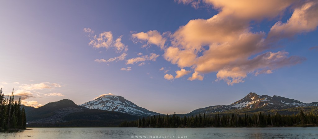
Nikon D780 24mm f8 1/100 sec ISO 100
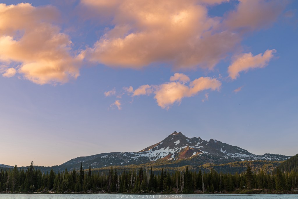
Nikon D780 48mm f8 1/60 sec ISO 100
As the light was fading and with no clouds over the either South Sister or Broken Top, we decided to load our gear in the car and walked the Ray Atkeson trail for about 30 minutes to scout a few spots to shoot on a future visit. We got back to the cabin at about 945pm and hit the sack.
The following morning, we rose early and got on the Cascade Lakes National Scenic Byway towards Sparks Lake. Along the way, we stumbled upon a picturesque location that offered a splendid view of the majestic Mt. Bachelor, accompanied by an abundance of vibrant pink and purple wildflowers adorning the roadside. We grabbed a few shots.

Nikon D780 35mm f18 1/5 sec ISO 100
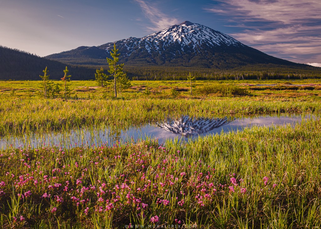
Nikon D780 38mm f8 1/25 sec ISO 100 (3 Image Focus Stack)
We drove around the area looking for more photo ops but didn’t find anything compelling. We then drove south to checkout other vantage points in other nearby lakes along the Byway. We located a good spot at he South Beach Picnic Area. There was nobody there. We located a bunch of rocks in the water close to the shore. I used it as an anchor to capture a decent image of South Sister.

Nikon D780 24mm f8 8 sec ISO 100 (10-stop ND filter, 2 Image Focus Stack)
Light was getting harsh and so we returned to the cabin at 9am. It was a productive morning, and all grabbed a few good images. We made breakfast and at around 10am. After breakfast, we then walked around the resort and the marina. After an early dinner at 5pm at the resort restaurant, we debated where to go for sunset. I was not thrilled to go back to Sparks Lake considering it was again a cloudless afternoon. We then decided to go to Lava Lake, another lake a few miles south of our cabin. Although the lighting was not impressive, we spent two hours walking around and shooting a few documentary shots.

Nikon D780 32mm f8 1/40 sec ISO 100 (3-Image Focus Stack)
As the sunset was not to our expectations, we returned to the cabin a bit early. We had about two hours to kill before we drove to a previously selected to photograph the Milky Way.
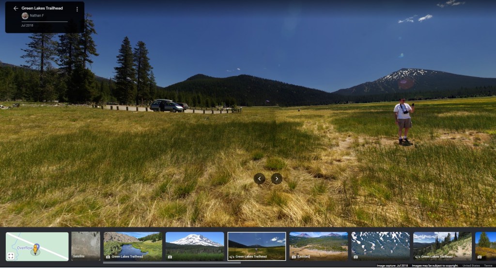
One of our trip goals was to photograph the Milky Way that requires extreme low levels of light pollution. Planning and selecting the optimum spot within 25 miles of our cabin was more interesting than photographing the Milky Way. The selection process included the following four steps:
(1) Use Google Maps Street View to traverse the Cascade Lakes National Scenic Byway and the side roads/trails connected to it and look for an open space with a mountain in the southern direction. (2) Make a list of spots on Flickr and other websites with images and location information and match them with spots identified in step (1).

(3) We utilized the PhotoPills app to determine the optimal time and location for capturing the galactic center of the Milky Way. According to the app’s calculations, the galactic center would rise above the horizon and visible from 11:16 pm until 2:59 am, providing us with approximately three hours of prime viewing and photography opportunities. Fortunately, the moon was not a concern, as it was due to set at 4:25 pm and rise again at 3:03 am the following day. This ensured that the moon’s illumination would not hinder our ability to capture the galactic center.
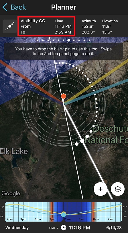
(4) Lock down the camera settings so that I don’t have to make too many adjustments in the dark. It is always a good idea to have the ability change any of the camera settings in pitch darkness. I decided on a focal length between 16mm and 24mm, f4.5, 25 seconds and ISO 5000. Later while processing, I realized that ISO of 5000 is way too low and the lowest ISO needs to be about 12000. Also the shutter speed should be under 20 seconds to minimize star trails.
It took me about 2 hours prior to the trip to nail down two possible locations. We selected one based on checking out both locations in the morning. We left the cabin at about 1130pm and drove to the selected spot. There was one car at the spot but it left soon after we parked our car. There was nobody else for the next 90 minutes. We all setup our tripods and cameras and shot a bunch of images for the next hour and a half. As we couldn’t see anything through the viewfinder or the rear LCD screen, we had to shoot-adjust-repeat.

Nikon D780 16mm f4.5 25 sec ISO 5000
We returned to the cabin at around 130am and I downloaded the Milky Way images into my laptop and quickly processed 2 of them to ensure the exposure and focus were okay. Thats when I realized that ISO 5000 was too low and that I should have set the ISO to 12,800. Also 25 second exposure was a tad long. The stars would look sharper with a 20-second exposure. Lessons learned.
Next morning, nobody was keen to get up at 5am to shoot sunrise. We got up late, had a late breakfast and checked out at around 11am. I grabbed a couple of shots at the marina.

Nikon D750 46mm f11 1/250 sec ISO 400

Nikon D750 50mm f11 1/250 sec ISO 400
It was close to noon when we left the resort. After 2 short breaks, we reached the final destination of the day, Union Creek Resort in Prospect, OR, about 25 miles southwest of Crater Lake. I had stayed at the lodge twice in the past and so it was a known entity. Interestingly, we found ourselves assigned the exact same two rooms as our previous visit back in 2017, when we had the unforgettable experience of witnessing the solar eclipse.
After a terrific dinner at Beckie’s Cafe across the road, we strolled along the Rogue river gorge. It was a challenge to photograph the river as the water was gushing too fast. I grabbed about 15 shots but trashed 13 of them. Here are the two images I kept.

Nikon D750 160mm f11 1/6 sec ISO 100

Nikon D750 155mm f11 1/6 sec ISO 100
We returned to the room at 9pm and called it a night.
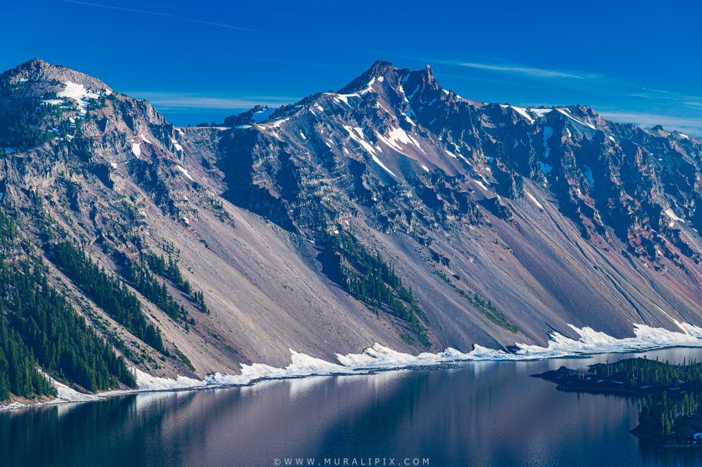
Next morning, we got up at 4am and left for Crater Lake in 30 minutes for a sunrise shoot. Usually, West Rim road opens in early June and the East Rim Road in early July. Unfortunately, the West Rim road was closed beyond Discovery Point, we decided to shoot sunrise from there. Finally, we got to experience good sunrise colors. All got some good shots.
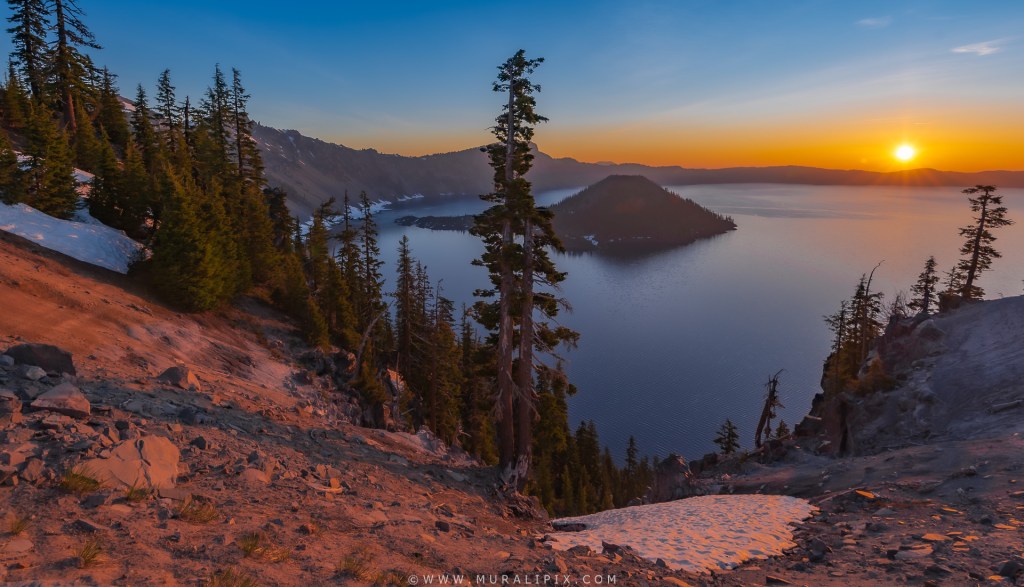
Nikon D750 16mm f8 ISO 100 (5-Image HDR stack)
Surprisingly, the light got too harsh about 30 minutes after sunrise, we decided to go to the Crater Lake Lodge for breakfast. We found out that the restaurant only opens at 7am and so we had about 45 minutes to wander around the area.
Nikon D780 100m f8 1/30 sec ISO 100
We went back to the Lodge at 7 and were seated immediately. After a slow and relaxed breakfast, we returned to our lodge, packed and checked out at 11am and started our drive to our last spot, Mitchell, OR, the gateway to the Painted Hills.

One response to “Central Oregon & Crater Lake Trip (Jun 12-17, 2023) Part 2”
Stunning pictures and enticingly written blog. Loved the Milky Way shot and the Mt Bachelor reflection on that tiny patch of water !!!
LikeLike